 Society

HCM City reports faster services after first year of two-tier governance reform
1.
Thousands of households living on the corridor of (Hồng) Red River dyke system in Hà Nội will likely be moved as part of the flood prevention plan, authorities and experts have said.
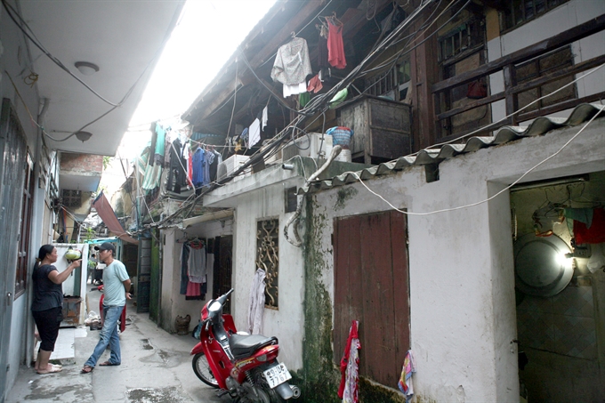 |
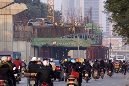
| Several old houses in Chương Dương Ward, Hoàn Kiếm District in Hà Nội which face a high risk of collapse in the event of a flood. Thousands of households living on the corridor of Red (Hồng) River dyke system in Hà Nội will likely be moved as part of the flood prevention plan. – VNA/VNS Photo Ngọc Hà |
HÀ NỘI – Thousands of households living on the corridor of (Hồng) Red River dyke system in Hà Nội will likely be moved as part of the flood prevention plan, authorities and experts have said.
The plan, recently approved by the Prime Minister, calls for renovating or relocating some 2,000 households along the river, which runs through Hà Nội’s wards of Chương Duong and Phúc Tân in Hoàn Kiếm District, Thanh Lương and Bạch Đằng in Hai Bà Trưng District, and Ngọc Thụy, Bồ Đề and Bát Tràng in Long Biên District, as well as other neighbouring areas of Võng La-Hải Bối, Đông Ngạc-Nhật Tảo, Bắc Cầu and Đông Ngàn.
Professor Hà Văn Khôi from the University of Water Resources spoke to Tiền Phong (Vanguard) newspaper, noting that the average water level continuously fell in the past decade, with the lowest recorded level of some 0.1m in 2010, creating favourable conditions for those households set a living along the river.
Meanwhile, a representative from the Bạch Đằng People’s Committee said these households were not included with the hundreds of illegal households built there since 1970.
The representative complained about the difficulties in relocating such households, as they were unprepared for the relocation and often seek to avoid cooperating with authorities.
Meanwhile, Dr Lê Viết Sơn from the Institute of Water Resources Planning said the new Government’s flood prevention planning scheme presented a very progressive subject, particularly for the population
residing outside the dyke system.
While providing prohibitions to those who violate the law on dyke protection or cause harm to dykes, the plan encourages households to reside and grow crops on islets or fertile lands along the river, according to the expert.
Earlier this year, Prime Minister Nguyễn Tấn Dũng approved a planning scheme for flood prevention and dyke systems along the Red and Thái Bình rivers.
The two rivers flow through 15 cities and provinces – Hà Nội, Hòa Bình, Hà Nam, Nam Định, Ninh Bình, Hưng Yên, Hải Dương, Thái Bình, Hải Phòng, Quảng Ninh, Phú Thọ, Vĩnh Phúc, Bắc Ninh, Bắc Giang and Thái Nguyên.
The plan aims to help the localities take the initiative in preventing floods and storms, contributing to their socio-economic stability as well as national security and defence.
It will also help relevant
ministries, agencies and localities manage efforts to prevent damage caused by floods and storms, and outline investment plans for related projects until 2030, with a vision towards 2050.
Apart from forecasting the flood tide in these areas, the scheme proposes anti-flood solutions and methods to effectively use river shores, in line with the Dyke Law and relevant legal documents, in the service of national socio-economic development. It further defines prioritised items and estimates resources necessary for the realisation of solutions.
From 2016-2030, efforts will be focused on planting administrative border markers along dyke corridors, completing operational procedures of large reservoirs located on the upper parts of the rivers, upgrading dykes, afforestation plans, as well as infrastructure and equipment supporting the work.
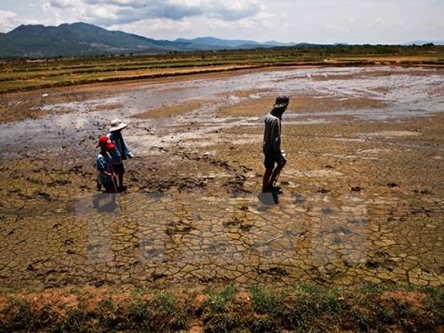
Many parts of Hồng and Thái Bình rivers in the north have seen its average water levels dramatically reduced – falling by 2m in 20 years. This has caused massive droughts among hundreds of thousands of hectares of farmland, blocked waterway transport and seriously polluted rivers. Experts said that the flow of the Hong River needs to remain at some 1,200 cubic metres per second to supply enough water for the Red River delta.
However, in the past several years the flow fell to 900 cu.m per second.
The River covers Hà Nội and 25 other provinces in the north, with a population of 26 million people and an agricultural area of nearly 1.1
million hectares. VNS
Society
 Society
 Society
 Society
 Society
 Society
 Society
Proper irrigation, including the use of alternative wetting and drying methods, will help protect crops during the ongoing drought and saline intrusion in the Cửu Long (Mekong) Delta.
 Society
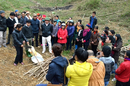
Until recently, growing grass to prevent soil erosion was beyond the imagination of many farmers in this northern mountainous region
 Society
Prime Minister Nguyễn Tấn Dũng has approved the funding of nearly US$224 million for Secondary Cities Development Project (Green Cities).
 Society
Company Limited China Railway Bureau Group 6, the main contractor for the Cát Linh-Hà Đông elevated railway project, was discovered to be skirting safety requirements and using workers who were not professionally trained.
 Society
Vice chairman of the HCM City People’s Committee said he hopes to strengthen co-operation with Finland’s investors, particularly in technology during a meeting on Wednesday with Lenita Toivakka, Finland’s Minister for Foreign Trade and Development in HCM City.
 Society
Doctors from Đồng Nai General Hospital have removed a 11kg tumour from the abdomen of a 100-year-old woman.
 Society
The Government has planned to spend about VNĐ 317 billion (US$14.2 million) yearly on offering preferential loans to disadvantaged medical graduates during their apprenticeship at hospitals
 Society
City polls 400,000 households for multi-dimensional poverty data collection
 Society
The Hà Nội People’s Court yesterday ordered the imprisonment of several bus drivers of the Thăng Long Bus Enterprise for robbery.