 Society

Prime Minister Nguyễn Xuân Phúc yesterday ordered the administrations of northern localities and the northern central province of Thanh Hóa, and relevant agencies to promptly brace for Typhoon Mirinae that hit the mainland later that day.
 |
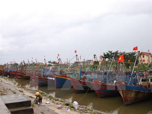
| Boats safely hide at the Tân Sơn Fishing Port in Thái Thụy District, Thái Bình Province. — VNA/VNS Photo Thu Hoài |
HÀ NỘI – Prime Minister Nguyễn Xuân Phúc yesterday ordered the administrations of northern localities and the northern central province of Thanh Hóa, and relevant agencies to promptly brace for Typhoon Mirinae that hit the mainland later that day.
Mirinae, the first storm to hit Việt Nam this year, is predicted to land in the provinces from Thái Bình to Nam Định in the evening and directly affect areas from the south of Quảng Ninh to the north of Thanh Hóa, according to the National Centre for Hydro-Meteorological Forecasting.
To prepare for the storm, the PM asked the coastal provinces from Quảng Ninh to Thanh Hóa to call on vessels working in the Tonkin Gulf to take shelter and ban boats from sailing offshore. They must evacuate people working on boats, aquatic farms, low-land areas and regions prone to landslides, while reinforcing houses and ensuring safety for mines, ports and tourism sites.
The mountainous provinces have to keep a close watch on rainfall developments to timely inform local administrations and residents about emergencies, ready evacuation plans in flood and landslide-prone areas, control waterway traffic, and release water in reservoirs already full to prepare for heavy rainfalls.
Meanwhile, low-land localities have to ensure the safety of dams, reservoirs and crops, and gear up for possible floods in cities.
The National Committee for Search and Rescue and the ministries of Defence and Public Security were requested to direct their subordinate bodies’ coordination with local authorities in evacuation, security protection, and search and rescue when necessary.
Other ministries were also asked to play their part in bracing for storm Mirinae.
 |
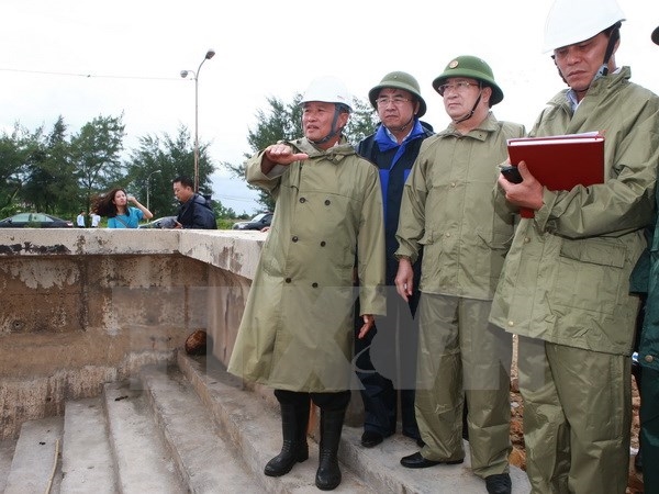
| Deputy Prime Minister Trịnh Đình Dũng inspects preparations in Hải Phòng City and visited dyke sections, ports and construction works in the northern coastal province of Thái Bình yesterday. — VNA/VNS Photo |
Also yesterday, Deputy Prime Minister Trịnh Đình Dũng inspected preparations in Hải Phòng City and visited dyke sections, ports and construction works in the northern coastal province of Thái Bình.
The Hải Phòng municipal People’s Committee reported that it had urged boats at sea to take shelter before 6pm, evacuated residents in susceptible areas, and banned waterway vehicles from operating from 10am the same day.
He asked local authorities to takes measures to ensure the lives of locals and safety for their property, promptly move residents from aquaculture zones, and call on ships to find shelter.
The deputy PM requested the local authorities to increase the inspection of irrigation works, and devise measures to prevent flooding, especially in cultivation areas.
He also underlined the necessity for the locality to follow information relating to storms, water levels in rivers and reservoirs, while asking local authorities to promptly evacuate residents from areas prone to landslides and flash floods.
According to Thái Binh’s border guard, 100 per cent of the locality’s ships have been called to move ashore to avoid the typhoon.
The northern mountainous areas had already experienced heavy rains from Tuesday evening after the storm hit the region.
At about 1pm yesterday, the storm was centred at about 20 degrees north latitude and 107.6 degrees east longitude, about 120km southeast of the seashore of Thái Bình and Ninh Bình provinces.
The eye of Mirinae was at about 20 degrees north latitude and 106.8 degrees east longitude, just off the coast of the two provinces. It sustained winds of up to 90km per hour.
Strong winds with gusts yesterday hit coastal areas from northern Quảng Ninh to Thanh Hóa and islands of Bạch Long Vĩ, Cát Hải, Cô Tô and Vân Đồn off the Gulf of Tonkin.
The storm caused heavy rains and strong winds across the capital city of Hà Nội yesterday afternoon.
According to the National Centre for Hydro-meteorological Forecasting, flash floods and landslides could hit all northern mountainous localities, especially Hà Giang, Tuyên Quang, Lào Cai, Yên Bái, Lai Châu, Sơn La, Điện Biên, Hòa Bình, Thái Nguyên, Bắc Kạn and Bắc Giang.
Meanwhile, flooding has been forecast to occur in low-lying and urban areas of Hải Dương, Ninh Bình, Thái Bình, Nam Định, Hưng Yên, Hải Phòng, Quảng Ninh and Hà Nội.
In the next three to 12 hours, the tropical storm will move west-northwest at about 15–20km per hour and abate into a tropical depression. At 4am Thursday, its centre is forecast to be in the northern delta with maximum winds of 60km per hour.
Thanh Hóa and the northern provinces have been warned of downpours, flash floods and landslides. Total rainfall will be between 100–200mm, even 300mm at some places. — VNS


