 Society


Deeper reforms needed to achieve target of 2 million firms
1.
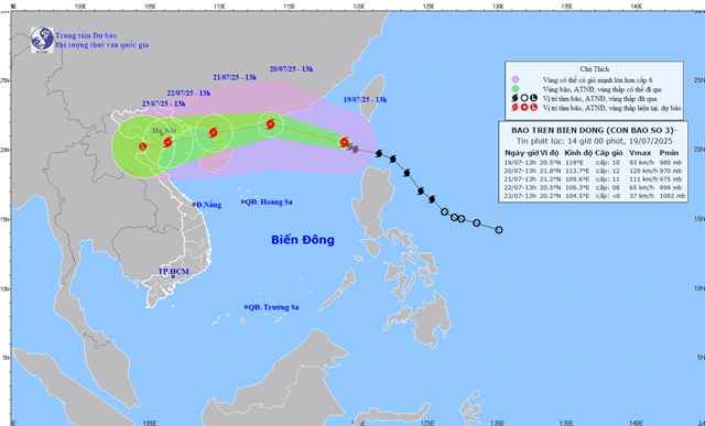 |
| Forecasted path of Typhoon Wipha. — Photo from the NCHMF |
HÀ NỘI — Typhoon Wipha, strengthening rapidly on July 19, has become the the year’s third tropical storm in the East Sea (internationally known as the South China Sea) and is forecast to bring strong winds, heavy rain and dangerous sea conditions across northern and north‑central Việt Nam in the coming days, according to the National Centre for Hydro‑Meteorological Forecasting.
At 7am on July 19, the storm’s eye was located at around 20.0° N, 119.8° E over the northeastern waters of the northern East Sea, packing maximum sustained winds of force nine (75–88kph) with gusts up to force 12 (on the Beaufort Scale). The system was moving northwest at about 20kph.
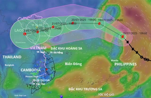
Forecasts show that by July 20 the storm will intensify further, with peak winds reaching force ten to eleven and gusts up to force thirteen as it moves west‑north‑west, about 600 kilometres east of China’s Leizhou Peninsula. On July 21 it is expected to track mainly west, hugging the eastern coast of Leizhou, with winds of force eleven to twelve and gusts up to force fourteen, before entering the Gulf of Tonkin on July 22 while weakening to force nine, gusting to force twelve. The disaster‑risk level remains at three throughout.
Under Wipha’s influence, winds over the eastern part of the northern East Sea are expected to freshen to force 6 to 7, increasing near the centre to force ten to eleven, with gusts up to force thirteen and waves rising to 4 to 6 metres, creating very rough seas. All vessels in these zones are warned of squalls, tornadoes, strong winds and high waves.
No complacency
Speaking to the Vietnam News Agency, Associate Professor Dr. Mai Văn Khiêm, director of the National Centre for Hydro‑Meteorological Forecasting, said the storm has already exceeded earlier intensity predictions. “At present, Storm No. 3 has reached level nine, one level higher than forecast 24 hours ago. It may reach levels twelve to thirteen, with gusts at level fourteen to fifteen, near the eastern area of China’s Leizhou Peninsula,” he noted.
Khiêm warned that strong winds and high waves would be the most immediate danger over the northern and central East Sea, especially around the Hoàng Sa Archipelago. Offshore areas such as Bạch Long Vĩ, Cô Tô and Cát Hải are expected to experience severe weather from July 20 to 21, while coastal areas from Quảng Ninh to Thanh Hóa will likely face direct impacts, including winds of level 7 to 9 (on the Beaufort scale), storm surge, and 3‑ to 5‑metre waves between July 21 and 23.
Heavy rainfall is expected across the North and from Thanh Hóa to Hà Tĩnh, with localised downpours potentially exceeding 150 millimetres in three hours. Rivers may rise by 3 to 6 metres, raising the risk of flooding, flash floods, and landslides in low‑lying and mountainous areas.
Khiêm urged authorities and residents to closely follow official forecasts and warnings, inspect vulnerable areas, prepare evacuation plans, and ensure traffic safety measures are in place. “Do not be complacent in response,” he said, emphasising that proactive measures and timely information are critical to minimising risks. — VNS
Society
 Society
 Society
 Society
 Society
 Society
 Society
 Society
 Society
 Society
 Society
 Society
 Society
 Society
 Society