Politics & Law
Việt Nam, China conduct joint patrol in northern Gulf of Tonkin
The activity aimed to strengthen coordination in combating crimes and legal violations at sea, particularly during the year-end period.
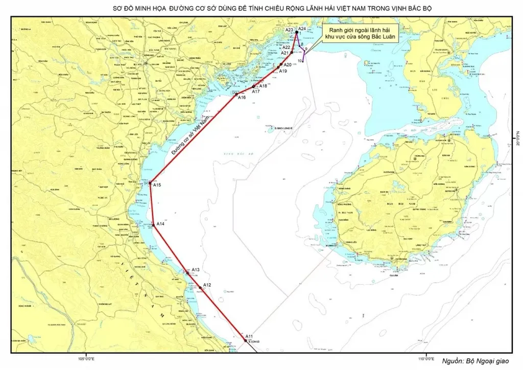 |
| An illustration of the baseline used to calculate the width of Việt Nam's territorial waters in the Gulf of Tonkin. — Photo courtesy of the Ministry of Foreign Affairs. |
HÀ NỘI — The Government of the Socialist Republic of Việt Nam has issued a formal declaration establishing the baseline used to calculate the width of Việt Nam's territorial sea in the Gulf of Tonkin.
According to a release on February 21 issued by the Ministry of Foreign Affairs, the announcement follows Resolution No. 68/NQ-UBTVQH15, dated February 14, 2025, issued by the National Assembly Standing Committee.
The establishment of the baseline in the Gulf of Tonkin aims to uphold Việt Nam's rights and obligations under the 1982 United Nations Convention on the Law of the Sea (UNCLOS) and aligns with Việt Nam's 2012 Law of the Sea.
The baseline has been determined based on UNCLOS regulations, reflecting the geographical and natural characteristics of the Gulf of Tonkin while ensuring compliance with international treaties to which Việt Nam is a party or member.
The baseline serves as a legal foundation for defining Việt Nam's maritime boundaries and the extent of its maritime zones in accordance with UNCLOS and the 2000 delimitation of the territorial seas, exclusive economic zones and continental shelves of the two countries in Beibu Gulf/Gulf of Tonkin between Việt Nam and China.
It provides a robust legal basis for safeguarding and exercising Việt Nam's sovereignty, sovereign rights and jurisdiction, contributing to economic development, maritime management, and enhancing international cooperation. — VNS
Politics & Law
 Politics & Law
 Politics & Law
 Politics & Law
 Politics & Law
 Politics & Law
 Politics & Law
 Politics & Law
 Politics & Law
 Politics & Law
 Politics & Law
 Politics & Law
 Politics & Law
 Politics & Law
 Politics & Law
 Politics & Law
 Politics & Law
 Politics & Law