 Society

 |
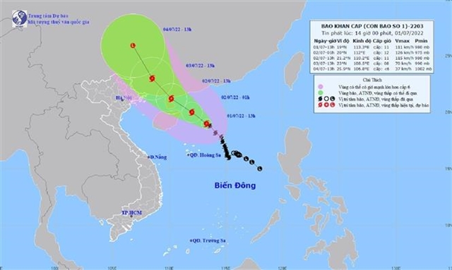
| Data from the National Centre for Hydro-meteorological Forecasting shows that by 10am on Saturday, the eye of the typhoon will be on the east coast of China’s Leizhou Peninsula, about 310km south-southeast of Quảng Ninh Province. — VNA/VNS Photo |
HÀ NỘI — Chaba, the first tropical storm to hit the East Sea this year, is predicted to gain more strength and cause torrential rain in the northern region between Saturday and Thursday.
Localities in affected areas are urgently preparing for the adverse weather conditions.
The National Centre for Hydro-meteorological Forecasting warned that heavy rain will hit the northeast region with rainfall from 40-90mm on Friday night.
Rainfall is predicted to be 100-200mm in the northern region and up to 150-300mm in the northeast region on Sunday and Monday.
The heavy rain will last until Thursday, the centre said.
Data from the National Centre for Hydro-meteorological Forecasting shows that by 10am on Saturday, the eye of the typhoon will be on the east coast of China’s Leizhou Peninsula, about 310km south-southeast of Quảng Ninh Province. The strongest winds near the eye of the storm are forecast up to 133km per hour.
The typhoon is moving northwest at 15km per hour, the centre said.
Due to the typhoon, the northern part of the East Sea has been hit by strong winds and high waves measuring 6-8m.
Seas will be rough from Saturday in the Gulf of Tonkin, including Cô Tô and Bạch Long Vĩ island districts, in the sea from Bình Thuận Province to Cà Mau Province as well as the central and southern part of the East Sea.
Coastal areas of the provinces from Quảng Ninh to Ninh Bình are likely to have high waves combined with high tides, affecting the sea dyke system and causing flooding in low-lying areas.
Nguyễn Văn Hưởng, head of the centre’s Climate Forecasting Department, said that the typhoon’s developments will be complex over the next 72 hours.
Therefore, vessels are told to not enter dangerous areas with strong winds and high waves caused by the typhoon, he said.
If they are in the dangerous areas, they must quickly seek safe shelter to anchor, he added.
Preparedness
In response to the situation, the National Steering Committee for Disaster Prevention and Control’s Office held a meeting to direct relevant agencies and localities to proactively respond to the typhoon on Friday morning.
Nguyễn Văn Tiến, deputy chief of the office, ordered agencies and localities to take measures to ensure safety for offshore vessels and people living in aquaculture areas, tourists and people on islands.
The agencies and localities are assigned to check drainage systems to protect agricultural production, low-lying areas, urban areas and industrial zones, he said.
Localities must plan to evacuate people living in high-risk areas of flash floods and landslides, he said.
The localities are ordered to ensure the safety of reservoirs, especially small hydroelectric reservoirs, key irrigation reservoirs for flood discharge; as well as arrange forces for emergencies, he added.
Under a report of the Border Guard Command, as of 6:30am on Friday, it has guided 59,967 ships with a total of 269,122 fishermen to find safe shelter. There were two vessels with 22 fishermen operating in a dangerous area near the typhoon. They were informed about the typhoon’s developments and they are seeking safety.
In Hải Phòng Province, local authorities have taken measures to prepare for the typhoon. Agencies are told to check the dyke system, mobilise all forces to prevent floods and deal with emergencies.
In Quảng Ngãi Province, the provincial Steering Committee for Natural Disaster Prevention and Control has sent a dispatch to urge relevant agencies to closely monitor the development of the typhoon in order to inform offshore vessels so that they could find safe shelter during the typhoon.
Rescue forces are told to be ready for emergencies, the dispatch said.
Data from the committee shows that as of 5am on Friday, there were still 979 local vessels with 7,621 fishermen still at sea. — VNS


