 Sunday/Weekend

The invisible tech powering our lives
1.
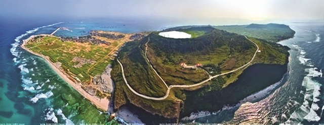 |
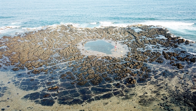
| TREASURED ISLAND: Lý Sơn and its geopark were formed by volcanoes from the prehistoric age. It is a 'natural museum' of volcanic activities. VNA/VNS Photo |
The ancient craters formed after millions of years of geological tectonics bestow a unique natural beauty on the coastal area along the central province of Quảng Ngãi, particularly the tourist island district of Lý Sơn.
Experts see Lý Sơn and its geopark, formed by volcanoes from the prehistoric age, as an extremely rare "natural museum" of volcanic activities.
Located off the northeast of Quảng Ngãi City, the island covers an area of about 10 sq. km with over 22,000 inhabitants. It has many strengths in geological, cultural and agricultural production and is a famed tourist destination.
The area currently has traces of 10 craters, of which three are located on the seabed. Research by experts from the Việt Nam Institute of Geosciences and Mineral Resources shows the volcanic cluster in Lý Sơn and its vicinity reveal many types of rock and lava typical for different eruption modes during the Quaternary period.
It is also home to the Hoàng Sa (Paracel) Flotilla, which protected the Hoàng Sa and Trường Sa (Spratly) archipelagoes four centuries ago. Every square metre on the island is imbued with the culture of its ancestors, who protected the sea hundreds of years ago.
"Lý Sơn island's structural rocks from the late Holocene age are divided into five categories from young to old stratigraphic units," according to research by Hà Quang Hải and Hoàng Thị Phương Chi from the Faculty of Environment, National University, HCM City.
In their research, the two experts explain the geomorphology is characterised by high-up cinder cones in the island having a funnel mouth, and basaltic flow forming a low cover at the foot of volcanoes. Marine terraces and beaches are mainly composed of calcarenite, and coral reef rocks are distributed around the island.
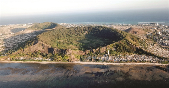 |
| GEOLOGICAL WONDER: The vestiges of Giếng Tiền crater in the west of Lý Sơn. This crater is hundreds of metres wide and 40m high, dating back about 1 million years. Photo tcdulichtphcm.vn |
Significant destruction of marine waves into the volcanic slopes and basalt flows forms interesting landforms along the island, such as sea cliffs, sea caves, rocky coasts, and stone towers.
"The most attractive is the Hang Cau - Chùa Hang cliff, which reveals a volcanic structural cross-section and the stratigraphic relationship between pyroclastic rocks overlaid on calcarenite layers," the researchers said.
The ancient craters of Hang Cau and Chùa Hang erupted about 9-11 million years ago, creating the island's foundation today.
The geological tectonics created original landscapes on the island, which are rare anywhere else in the world. Among the beautiful sites are Hang Cau, Tò Vò Arch, Giếng Tiền and Thới Lới craters, which have significant scientific and tourist value.
Many other scientific studies on the geological conditions of Lý Sơn have highlighted the "dual crater" on the top of Thới Lới mountain, praising it as one of the most attractive landscapes for tourism development in the island district.
The crater has a stunning lake on top of the mountain that erupted about a million years ago, with a diameter of 0.35km and a height of 149m.
Along the coast of Quảng Ngãi, a series of volcanic sedimentary rocks stretching for kilometres through the city of Quảng Ngãi and areas near districts of Sơn Tịnh and Bình Sơn have become amazing check-in destinations for tourists.
In 2015, Quảng Ngãi established Lý Sơn-Sa Huỳnh geopark to conserve the rich biodiversity and geological, cultural and historical values of the island. The park covers the island and adjacent coastal areas in Bình Châu and Bình Hải communes, Bình Sơn District, with Lý Sơn as its core.
In late 2019, the province's authorities submitted dossiers to the United Nations Educational, Scientific and Cultural Organisation asking for the recognition of Lý Sơn as a UNESCO geopark.
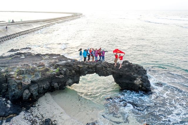 |
| RUGGED COAST: Tò Vò Arch, an attractive destination in Lý Sơn. The geological tectonics created original landscapes on the island, rare anywhere else in the world. Photo tcdulichtphcm.vn |
Community tourism
Economic development focusing on tourism is one of the key targets of Lý Sơn, according to the district authority.
Lý Sơn will give priority to tourism when allocating resources for socio-economic development, said Đặng Tấn Thành, vice chairman of the district People's Committee.
According to Thành, the local economic structure is shifting towards sustainability and a larger proportion of the trade-service sector. Tourism has been earmarked for breakthrough development, becoming a key economic sector in Lý Sơn.
The district has targeted raising the share of the tourism-service sector in the local economy to 60 per cent. In comparison, agriculture will account for 30-35 per cent and industry-handicrafts the remaining 5-10 per cent.
The authorities plan to focus on completing the district's development master plan, which will be the basis for attracting investment over the next five years.
To this end, the locality has built a new central market and developed a diverse and affordable homestay network, dining, and transport services meeting the demand of locals and tourists to the island.
It is now tapping its tourism potential by conserving local relics, creating spiritual tourism, promoting historical and scenic sites, and protecting the environment by constructing a waste treatment plant.
"Lý Sơn is exploiting its potential to develop this economic sector, and community-based tourism is a way to preserve and promote the value of relics and heritage on the island," said a report from the website of the district People's Committee.
A new model of community tourism titled 'Kỳ Bí Đảo Núi Lửa Lý Sơn' (Mysterious Lý Sơn Volcanic Island) promises to open up a new direction for the development of professional and sustainable tourism.
The model takes advantage of agricultural activities, especially harvesting onions and garlic, traditional fishing, culinary activities and tours to mysterious destinations on the volcanic island.
It also makes use of secret stories about Lý Sơn's nature, culture and people stirring up the imagination of visitors.
Through this new model, tourists will have a broader view of the island's geological and historical development and be amazed at experiences in the fields of onions and garlic, which are so typical of the area.
More than 120 tourism enterprises and units, including those from restaurant services, hotels, homestays and transportation companies, have joined the model.
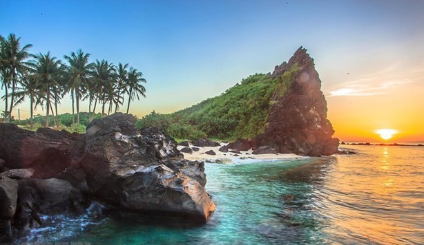 |
| PARADISE: The natural beauty on the tourist island district of Lý Sơn. VNA/VNS Photo |
Participating tourism businesses and agencies will be supported in promoting their image and guided on how to do professional community tourism.
Developed by the Quảng Ngãi Province's Department of Culture, Sports and Tourism, the University of Social Sciences and Humanities under the National University in HCM City, and Lý Sơn District People's Committee, the model is expected to fully exploit the potential of the island and improve the quality of tourism.
 |
| TWISTED ROCK FORMATIONS: An ancient crater in Ba Làng An Cape is about 30m wide. Here, the ecological topography extends to the surrounding area with many basalt fields. Photo tcdulichtphcm.vn |
Bùi Văn Tiến, deputy director of the culture, sports and tourism department, said it would accompany the People's Committee of Ly Son in strengthening the development of the model in local areas as well as throughout the country and abroad.
"We will let visitors know about Lý Sơn as a wild, interesting, clean and beautiful destination," Tiến said. VNS
Sunday/Weekend
 Sunday/Weekend
 Sunday/Weekend
 Sunday/Weekend
 Sunday/Weekend
 Sunday/Weekend
 Sunday/Weekend
 Sunday/Weekend
 Sunday/Weekend
 Sunday/Weekend
 Sunday/Weekend
 Sunday/Weekend
 Sunday/Weekend
 Sunday/Weekend
 Sunday/Weekend