 Society


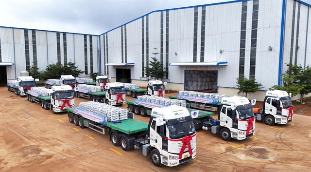
Việt Nam advances deep processing with first aluminium ingot production
1.
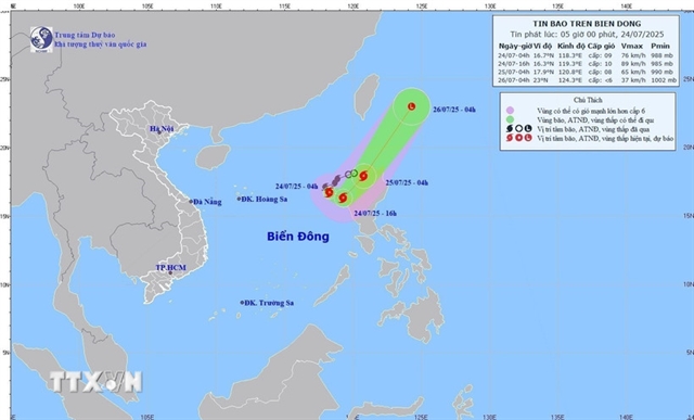 |
| The direction of Storm No. 4. — VNA/VNS Photo |
HÀ NỘI – Việt Nam's Typhoon No.4 is forecast to move east-southeast at a speed of 10-15km/h, with the eastern part of the northern East Sea region forecast to see winds at levels 9-10, gusting at level 12 by 4pm on Thursday (July 24).
As of 4am on Thursday, the storm's centre was located at approximately 16.7°N latitude and 118.3°E longitude over the northeastern East Sea (internationally known as the South China Sea) region, according to the National Centre for Hydrometeorological Forecasting.
The strongest winds near the storm's centre were at levels 8-9 (62-88km per hour), gusting at level 11. The storm is moving in a south-southeastern direction at around 15km/h.
By 4pm today, the storm is forecast to move east-southeast at a speed of 10-15km/h and in the eastern sea of the northern East Sea region, winds will be at levels 9-10, gusting at level 12.
The affected area is the northeastern East Sea region. Disaster risk is at level 3.
By 4am on Friday, July 25, the storm is forecast to change direction to the northeast, moving at 20-25km/h, and will reach the northern land area of Luzon island in the Philippines with winds at level 8, gusting at level 10. The affected area will still be the eastern sea of the northern East Sea.
The storm is expected to continue moving northeast at 25-30km/h and gradually weaken into a low-pressure area by 4pm on Saturday.
Due to the influence of Storm No 4, the northeastern East Sea area will experience strong winds at levels 7-8, with the storm's centre reaching levels 9-10, gusting to level 12. Waves will reach heights of 4-6m. The sea will be very rough. Vessels operating in the above danger zones will likely face thunderstorms, tornadoes, strong winds and high waves.
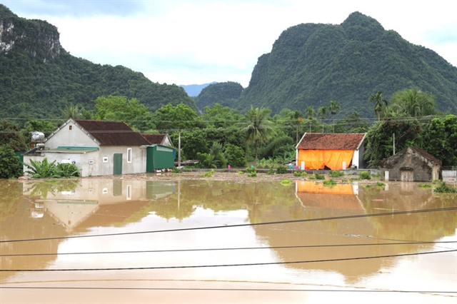
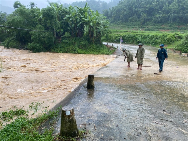
Risks of flash floods, landslides
The northern region of Thanh Hóa and Nghệ An provinces will likely see moderate to heavy rain and thunderstorms, with localised extremely heavy rainfall ranging from 60-130mm, and in some areas over 250mm from July 24 through the night of July 25.
Meanwhile, Tây Nguyên (the Central Highlands) and southeastern regions are expected to see showers and thunderstorms, with some locations receiving 15-30mm of rain, and others exceeding 80mm. Thunderstorms may bring tornadoes, lightning, hail and strong gusts.
Heavy rain may cause flooding in low-lying areas, urban centres and industrial parks, as well as flash floods in small rivers and streams and landslides on steep slopes.
There is a high risk of flash floods and landslides in many areas in the provinces of Sơn La, Phú Thọ, Lào Cai, Thanh Hóa and Nghệ An. — VNS
Society
 Society
 Society
 Society
 Society
 Society
 Society
 Society
 Society
 Society
 Society
 Society
 Society
 Society
 Society
.jpg)