 Society


|
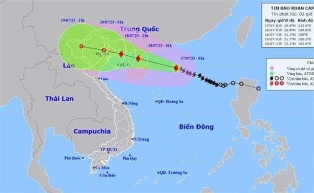
| The movement of storm Talim. — VNA/VNS Photo |
HÀ NỘI — Prime Minister Phạm Minh Chính on Sunday asked ministries and localities to concentrate on measures in response to storm Talim, the first storm expected to hit Việt Nam this year.
According to the National Centre for Hydro-meteorological Forecasting, at 4am on Monday, the storm was 380km to the east–southeast of China's Leizhou Peninsula with a wind speed of 103-117km per hour and gusts up to 166km per hour.
By 4am on Tuesday, the storm will have tracked mostly west-northwest with at a speed of 15km per hour and gained strength. The storm will be about 310km to the east of Hải Phòng City of Việt Nam.
The northern area of the East Sea, including the Hoàng Sa territorial waters, will experience heavy rain throughout Monday.
The southern area of the Gulf of Tonkin, the middle and southern areas of the East Sea, including the Trường Sa territorial waters, the sea from Bình Thuận to Cà Mau, Cà Mau to Kiên Giang, and the Gulf of Thailand will all experience strong showers and thunderstorms.
The PM sent the request to the chairpersons of the People's Committees of the provinces and cities across the country.
Various ministries were also asked to take response measures for the storm together with the National Steering Committee for Natural Disaster Prevention and Control and the National Committee for Search and Rescue of Việt Nam.
Responding to the coming storm, authorities in the northeastern coastal province of Quảng Ninh requested units and localities to keep contact with boats operating at sea, providing them with information on the location and storm movements to actively instruct them to reach safe shelters and away from dangerous areas.
The province also asked aquaculture growers to urgently consolidate their aquaculture cages and local authorities were asked to evacuate people from aquaculture areas with priority given to women, the elderly, and children. The evacuation must be completed before 4pm on Monday.
Localities, especially those on islands, were asked to review the number of tourists and provide them with proper information about the storm.
Relevant authorities and agencies must review the landslides-prone locations to have specific response plans; organise the opening of the drainage system, particularly in urban areas. Localities in mountainous areas must be ready to respond to floods and landslides.
Meanwhile, the coastal city of Hải Phòng also took storm-response measures to ensure safety for people, aquaculture production, fishing vehicles, and infrastructure in vulnerable areas of coastal areas or mountainous ones.
Nguyễn Văn Hưởng, head of the Weather Forecasting Department at the National Centre for Hydrometeorological Forecasting, said storm Talim would directly affect Quảng Ninh and Hải Phòng on Tuesday and Wednesday.
However, another possibility is that the storm, after passing through Leizhou, will deviate to the south and expand the effect to the south of the northern delta. This scenario has a low probability but needs to be kept in mind, Hưởng said.
In addition to strong winds, the storm will cause prolonged heavy rains in the northern region, so Hưởng suggested localities prepare for heavy rains and urban flooding. The storm can also cause flash floods and landslides in northern mountainous provinces.
"We could see consecutive days of rainstorms, increasing the risk of flash floods and landslides from Tuesday in the northern region, especially in provinces like Lạng Sơn, Cao Bằng, Hà Giang, Lào Cai, and Yên Bái," Hưởng said as quoted on vnexpress.net. VNS


