
National Assembly approves Nguyễn Tiến Hải as Minister of Home Affairs
1.
Samples of basalt and ancient rocks found on mountains and cliffs on the Lý Sơn Islands have shown that there were active volcanoes in the area less than 10,000 years ago, and researchers believe it is possible they could erupt again.
|
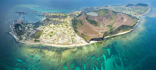
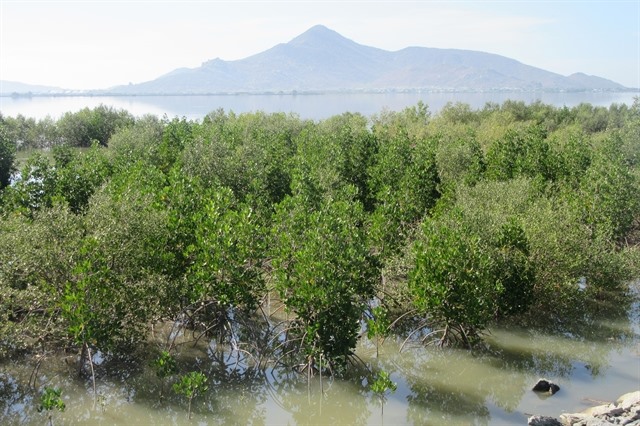
| An overview of Lý Sơn Islands, off the coast of Quảng Ngãi Province, the islands was formed by five volcanoes millions of years ago. However, geological experts say the volcanoes could become active in the future. Photo courtesy of Bùi Thanh Trung |
LÝ SƠN ISLANDS — Samples of basalt and ancient rocks found on mountains and cliffs on the Lý Sơn Islands have shown that there were active volcanoes in the area less than 10,000 years ago, and researchers believe it is possible they could erupt again.
Experts from the Việt Nam Institute of Geosciences and Mineral Resources (VIGMR) said recent field surveys showed that craters on the islands were round and sharp, suggesting the volcanoes were very young.
The last volcanic eruption here was recorded in the central coast of Việt Nam, 100km off the south central coast of Phan Thiết City in Bình Thuận Province, where it formed the Hòn Tro, or Ile des Cendres (Island of Ashes, or a group of submarine volcanoes) in 1923.
Dr. Nguyễn Xuân Nam from VIGMR said rock samples collected from Thới Lới Mountain show they dated 20,000 years ago, while basalt samples at the other volcanoes were formed less than 10,000 years ago.
“Following data and surveys from the national research project on the Neo-tectonic in previous years, coastal areas of Quảng Ngãi Province are situated in high risk centre of active fault, including of earthquakes and volcanic eruptions ranging from Thừa Thiên-Huế to Bình Thuận,” Nam said.
“Lý Sơn Islands terrain structure could shake due to active volcanoes putting big construction buildings in danger.”
He said at least nine points of thermal water were found in the province, evidencing of a deep breakable ground structure.
|
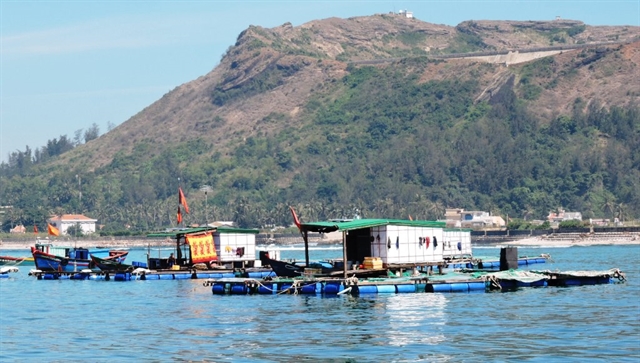
| Aquatic farms have been developed in the sea off Lý Sơn Islands of Quảng Ngãi Province. Photo courtesy of Trần Lan Anh |
“Construction of a small building only needs ground stability tests, but high-rise buildings must be developed using a deep terrain structure assessment for quake resistance structure plans,” he said.
Volcano forecasts are not yet available in Việt Nam, but Lý Sơn Islands and coastal zones in Quảng Ngãi are marked as the volcanic centre, he added.
Nam said five underwater craters were found in the water off the islands, and two others were seen at Mù Cu Islet. So, possible active volcanoes could impact any construction projects on the islands.
He also said a group of researchers and scientists had found a population of paleontological coral reefs over an area of 20,000 square metres extending 400 metres along the coast, northeast of the islands.
It’s a unique complex of fossilised coral – believed to date from 4,000 to 6,000 years ago – on the islands’ coast, he added.
Trần Tân Văn, an expert in geology, said nobody could be sure if volcanoes would become active on Lý Sơn Islands or not, but craters on the islands were identified as young and active volcanoes.
Active volcanoes
World volcanologists believe that if the last eruption of a volcano took place less than 10,000 years ago, it should be considered an active volcano, which can erupt anytime in the future.
Trần Tân Văn said active volcanoes in Việt Nam might be related to the Manila trench subduction zone (an active convergent plate margin between the East Sea and the northern Philippines).
This means that volcanoes could occur in the coastal central region of Việt Nam in linkage with the active tectonics along the Manila trench.
He said the Ministry of Natural Resources and Environment compiled a map on tsunami and earthquakes in the coastal central Việt Nam a few years ago, and only earthquake measurements and a tremor monitoring system were established, but an early quake warning system was not yet built.
|
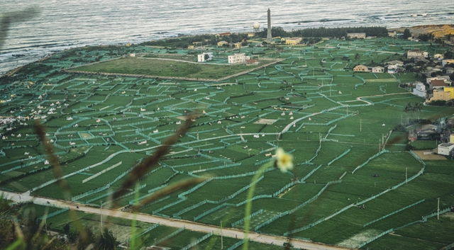
| The islands of ancient volcanoes are a favourite tourist destination in the province. Photo courtesy of Lê Xuân Thọ |
Văn, who is former director of VIGMR, said a series of construction projects on the islands should include seismic and tsunami factors in the plan.
At a scientific seminar in the province few years ago, Dr. Setsuya Nakada, chair of the Advisory Committee of the Global Geo-Parks Network, said at least five volcanoes and potentially active volcanoes occurred in central and south of Việt Nam in the Neogene-Quatenary period.
He said volcanic activities in Việt Nam were related to the subduction zone (Ring of Fire in Pacific region), and the formation of the East Sea.
|
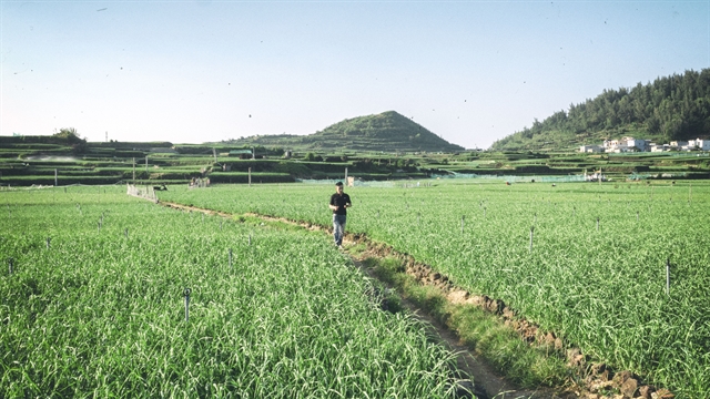
| Most of the 22,000 population on the islands make their living from garlic farming. Photo courtesy of Lê Xuân Thọ |
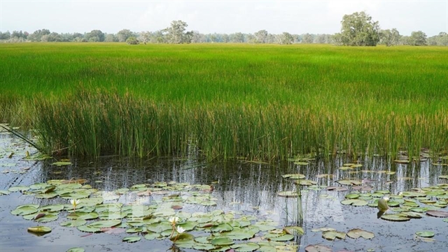
Lý Sơn island, known as the ‘Kingdom of Garlic’ in Việt Nam, is a tranquil destination with 22,000 inhabitants, most of whom make their living from garlic, spring onions and fishing.
Conservationists and scientists have warned that booming construction, mass tourism and proposals for an airport could damage the terrain structure, and that new buildings must be resistant to quakes and tsunamis.
Tourism has boomed since the islands connected to the national grid in 2014, hosting 260,000 tourists each year and creating VNĐ317 billion (US$14 million) in revenue.
According to the latest report from the island, 14 hotels, including one four-star hotel, 57 guest houses and 62 homestays are open, offering more than 1,000 rooms for up to 3,000 tourists.
The 10.4 square kilometre islands have invested VNĐ800 billion in developing 17 infrastructure projects in the last 10 years. — VNS
 Environment
 Environment
 Environment
 Environment
 Environment
 Environment
 Environment
The south-central province of Ninh Thuận this year plans to increase its forest-cover rate to nearly 50 per cent, including 330 hectares of new special-use forest and protection-forest planted in response to climate change.
 Environment
Lê Minh Tuyên, Director of the Hà Nội Forest Protection Division under Hà Nội Agriculture and Rural Development Department, spoke to Hà Nội Mới (New Hà Nội) newspaper about difficulties and challenges in forest management and protection.
 Environment
As the healthcare professionals are racing to save lives in Bình Dương, environmental workers are also on the front line to make sure COVID-19 related waste from hospitals, quarantine facilities and locked down areas is properly collected and treated to prevent risks of disease transmission in the community.
 Environment
Rapid urbanisation have led to increasing demand for housing and infrastructure. Consequently, ponds and lakes across the city have been filled to make room for construction.
 Environment
Hạ Long City, a popular tourist destination in the northern coastal province of Quảng Ninh, will implement a series of measures to classify, collect, transport and treat domestic and construction waste from early next year.
 Environment
 Environment
A group of bio-researchers at Đà Nẵng’s technology and education university have started a bio-based waste treatment project using water released from fishing boats at Thọ Quang dock, promising 98 per cent of pollutants will be purified