 World
World

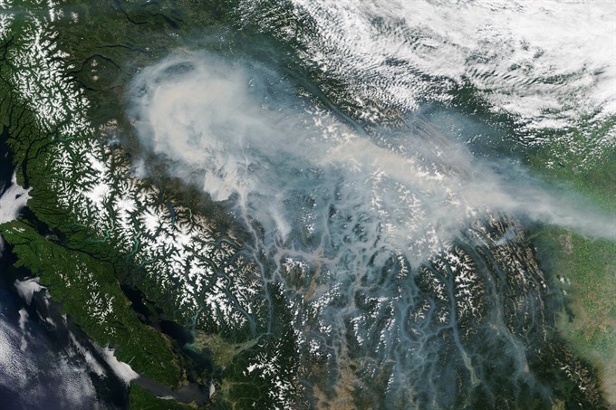
Nineteen wildfires have merged into one massive forest fire that officials said Tuesday was the largest ever recorded in Canada's westernmost British Columbia province.
 |
| A handout photo made available by NASA on Sunday shows an image captured by the Moderate Resolution Imaging Spectroradiometer (MODIS) on NASA’s Terra satellite of smoke blanketing Canada’s westernmost province of British Columbia on 18 July 2017. As smoke spread across the region, Environment Canada issued air quality advisories for large parts of British Columbia and Alberta provinces. — EPA/VNA Photo |
OTTAWA — Nineteen wildfires have merged into one massive forest fire that officials said on Tuesday was the largest ever recorded in Canada’s westernmost British Columbia province.
The fires combined into a single blaze west of Quesnel that covers 467,000ha -- twice the size of the previous record holder that was more than 200,000ha in 1958.
The so-called Plateau wildfire stretches 130km from end to end, and despite efforts by hundreds of firefighters, it is expected to continue burning for some time.
"This is the largest fire in the province’s history," British Columbia chief wildfire information officer Kevin Skrepnek told a briefing.
Although it has not grown further over the past 24 hours, he added, "This fire has potential for growth."
A state of emergency has been in effect in British Columbia since July 7.
Most of the 46,000 people who were forced to flee have been able to return to their homes, but nearly 2,700 are still subject to evacuation orders.
As of Tuesday, there were 134 active fires in British Columbia. Some 3,900 firefighters and support crews, as well as 200 aircraft, have been mobilised.
Since April, more than 1.2 million hectares of British Columbia forests have been destroyed by fire.
"This is the highest area of land burned that we’ve ever had in the province’s history stretching back to 1912," when wildfire tracking began, Skrepnek said. — AFP


