.jpg) Opinion
Opinion

 |
| Dr Trần Hồng Thái, director general of the Việt Nam Meteorological and Hydrological Administration. — VNA/VNS Photo |
Dr Trần Hồng Thái, director general of the Việt Nam Meteorological and Hydrological Administration (VNMHA), speaks to Dân Trí e-newspaper about the progress in hydrometeorological forecasts and efforts to make these reports more accessible to the public.
Are the increasingly extreme and unusual weather phenomena in recent years a challenge for hydrometeorological forecasting?
In any country, hydrometeorological forecasting plays an important role that affects most sectors and socio-economic aspects.
According to a World Bank report in 2021, if low- and middle-income countries had advanced hydrometeorological systems like those in Europe, the annual deaths and financial losses caused by natural disasters could be reduced by 23,000 people and between US$300 million and $2 billion. Economic profits from providing information to various industries could reach between $3-30 billion.
On a global scale, hydrometeorological data is estimated to decrease the annual damage due to natural disasters by up to $66 billion.
Hydrometeorological forecasting has always been challenging and will be even more so due to climate change impacts. Global data over the past 50 years show that extreme climate and weather phenomena are rising in terms of both intensity and frequency.
Regarding climate change impacts, scientists have pointed out that there will be bigger storms and more intense summer heat in the future. Places with low levels of precipitation will become more arid, while locations with high rainfall see more heavy rain and severe floods.
Weather forecasting is facing significant challenges. This is not only the case in Việt Nam but also major weather forecasting centres in countries with more advanced science and technology levels. People need to follow the latest forecast data to have the most credible information that will help minimise damage.
There were many times when the public was sceptical about the quality and accuracy of the forecasts. What is your opinion on this matter?
It must be said that natural disasters have unpredictable complications and can change very quickly in terms of both intensity and area of impact. Scientists cannot accurately determine the exact locations to be affected or the specific level of danger, but we can only provide information on the general area and the possibility of impacts.
Therefore, the challenge of responding to natural disasters is about natural disaster risk management, meaning that we must anticipate possible risks from the lowest to highest levels. On that basis, we prepare thorough response plans so that no matter what the level of the disaster, we are prepared and ready to take action. This is common across the world and Việt Nam is on its way. It is extremely dangerous to be in a passive position when responding to natural disasters.
In fact, in recent years, with the government’s funding, the VNMHA’s monitoring systems, data and storm forecasting work have seen progress. Forecast reports have been improved in terms of time and credibility.
During the prolonged floods in 2020 or the severe drought in 2019-2020, the Prime Minister and the National Steering Committee for Natural Disaster Prevention and Control recognised and gave high regard to the hydrometeorological sector’s forecasts.
Or in the case of super typhoon Noru in 2022, based on data analysis and calculations from international forecasting centres, we provided advice on the possible intensity of the typhoon on the East Sea (internationally known as the South China Sea). With that information, the National Steering Committee for Natural Disaster Prevention and Control, local authorities and departments were able to have prompt responses with no unfortunate damage.
 |
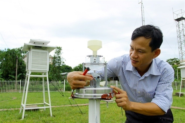
| Staff at the North-central Regional Hydrometeorological Station perform maintenance on a weather monitoring device. — VNA/VNS Photo Thế Duyệt |
What innovations has VNMHA applied for more accurate weather forecasts and warnings?
The hydrometeorological sector has extended the time range for weather forecasts and early warnings of natural risks to 10 days, while the content and format of the reports are also updated, focusing on a more detailed scale over a longer period of time.
Seasonal forecasts are also reported over an extended period, and there are now regular natural disaster assessments (twice per year).
Storms and tropical depressions are forecast three days prior, while a warning is issued five days in advance.
Warnings are issued two to three days in advance for heavy rain, 30 minutes to three hours in prior for thunderstorms, and five to seven days in advance for severe and harmful cold spells.
Thanks to this, response plans are done earlier and more proactively.
Marine weather forecasting has seen significant progress with the application of advanced forecasting technologies. The wave forecast model now has a detailed spatial resolution of 4km for a duration of 10 days.
Each storm forecast report is also published 30 minutes to an hour earlier than in the past. Other reports on heat waves, cold spells and heavy rain are all issued 30 minutes earlier than before.
In addition to information about the weather phenomena, the reports also include their impacts on the environment, living conditions, infrastructure and socio-economic activities.
According to our preliminary evaluation, including the additional information on possible impacts in forecasts has helped natural disaster steering teams be more proactive in implementing response plans.
What is your evaluation of forecasts and warnings for natural disasters, storms, floods and landslides that have occurred in multiple locations recently?
Among natural disasters, there are types whose developments can be traced such as tropical depressions, or storms and floods on major rivers. However, there are also the types taking place on a very narrow scale that is difficult to predict, such as flash floods, landslides, tornadoes and lightning.
Issuing detailed warnings of flash floods and landslides for each residential area and village to minimise damage is a challenge for not only Việt Nam, but also countries with advanced technology such as Japan or the US. With the current technology, the world is not yet able to predict flash floods and erosion at a particular location or point in time.
Several provinces have now conducted surveys to identify hotspots for flash floods and landslides. Then, the hydrometeorological agency’s report will include the details in the warnings issued to specific villages and locations at risk. For provinces that have not conducted these surveys, the warnings will be detailed to the district level.
In the case of the Bảo Lộc Pass landslide (in Đại Lào Commune, Bảo Lộc City, Lâm Đồng Province) on July 30, from July 27, Lâm Đồng Provincial Hydrometeorological Station had issued warnings that Đại Lào Commune was at high risk of erosion. Warning bulletins issued on July 29-30 also highlighted that Bảo Lộc Pass is an area at risk of landslide.
Regarding the recent flash floods in Sa Pa (Lào Cai Province), the hydrometeorological agency issued warnings and localities took preventive measures, but unfortunately, there were still casualties and property damage.
 |
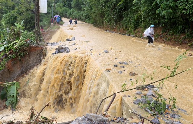
| Flash floods occurred in the mountainous Lào Cai Province in mid-September, killing seven people. —VNA/VNS Photo Quốc Khánh |
What measures has VNMHA taken to better deliver forecasts to the public?
In the past, most hydrometeorological forecasting work was focused on dangerous natural disasters such as typhoons, tropical depressions, heavy rain, heat waves, severe cold spells and floods.
Since 2016, forecasts of dangerous hydrometeorological phenomena and various natural disasters have increased significantly to include typhoons, tropical depressions, widespread heavy rain, floods and inundation, land erosion and subsidence due to heavy rain or flows, cold spells, heat waves, drought, saline intrusion, thunderstorms, tornadoes, hailstorms, coastal fog, high waves and water surges during tropical depression, as well as monsoon and tidal floods.
In addition, forecast reports have been improved to serve multiple purposes, and there have been forecasts on the impacts and risk warnings according to actual needs.
In terms of communication formats, in addition to periodic forecasts and warnings, the hydrometeorological sector has been working on an online channel to provide information on flash floods, landslides and extremely short-term thunderstorms, which is updated every hour on the VNMHA e-portals at luquetsatlo.nchmf.gov.vn and amo.gov.vn.
The VNMHA also maintains its social media accounts such as on Facebook at facebook.com/NCHMF and facebook.com/tongcuckhituongthuyvanVN for information updates in case of natural disasters to deliver warnings to people as soon as possible to minimise natural disaster-induced damage. — VNS