 Politics & Law

 |
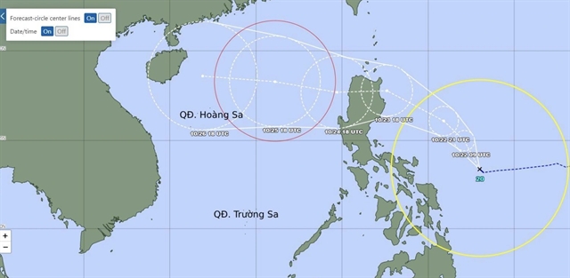
| The forecast path of Typhoon Trami. — Photo jma.go.jp |
HÀ NỘI — While central Việt Nam continues to grapple with heavy rainfall, typhoon Trami is making its way towards Việt Nam.
According to the forecast, the typhoon is expected to cross Luzon Island (Philippines) and enter the East Sea (internationally known as the South China Sea) around October 25, becoming the sixth storm to do so in the year, prompting an urgent call for preparedness.
Before the typhoon's arrival, heavy rains are expected to batter central Việt Nam on Tuesday.
The regions from Quảng Trị to Phú Yên are forecast to experience heavy downpours, with localised rainfall intensifying to over 90 mm.
Torrential rains are also expected to hit the regions from Thanh Hóa to Quảng Bình, with rainfall levels ranging from 20 to 40mm.
The forecast also shows that scattered thunderstorms and moderate rainfall would affect the Central Highlands and Southern Regions.
Significant wave heights of up to 5m are expected, accompanied by severe thunderstorms and the potential for tornadoes.
In response to the imminent typhoon, the Ministry of Agriculture and Rural Development has sent an urgent telegram to local authorities and relevant ministries, calling for emergency measures.
Coastal provinces are urged to closely monitor weather reports and inform fishermen and vessels at sea to take necessary precautions. Plans to protect lives and property must be underway, with emergency rescue teams and communication systems on standby.
On land, the Ministry urges evacuation plans for those in high-risk areas. Additionally, local forces must be quickly deployed to ensure traffic safety in regions affected by floodwaters and landslides.
Critical infrastructure such as roads, bridges, and reservoirs, must be under close surveillance, with repair teams ready to respond to any incidents. — VNS


