 Society

Typhoon Hato, the sixth storm to hit East Sea this year, will cause heavy rains in the northern provinces from Wednesday to Friday, after it makes a landfall in China.
 |
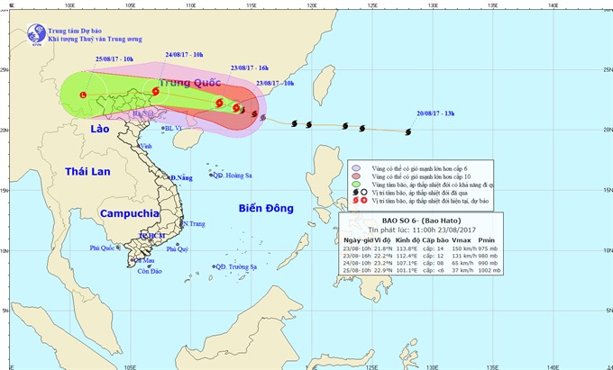
| Photo shows the direction of storm Hato. — Photo nchmh.gov.vn |
HÀ NỘI — Typhoon Hato, the sixth storm to hit East Sea this year, will cause heavy rains in the northern provinces from Wednesday to Friday, after it makes a landfall in China.
According to the National Centre for Hydro-Meteorological Forecasting, at 4am on Wednesday, the eye of the storm was 190km away from southeast Hong Kong and the wind level was 13, which means wind speed of up to 135-150km per hour.
The storm is expected to make a landfall in south China’s Guangdong Province on Wednesday noon and then start weakening.
At 4am on Thursday, the eye of the storm will be over the southern part of China’s Guangxi Province, and wind level is forecast to be between level 10 and 12.
Early Friday morning, the storm will become a low pressure system and its centre will be around the border between Việt Nam’s north-western provinces and China’s Yunnan Province.
Because of the storm, the Bắc Bộ (Tonkin) Gulf has been experiencing rain and thunderstorm since Wednesday morning. The island districts of Cô Tô and Bạch Long Vĩ, to the north of Bắc Bộ Gulf, may see wind levels of 7 to 9, rough seas and waves that are two to three metres high on Thursday morning.
Heavy showers are expected in Quảng Ninh, Lạng Sơn, Cao Bằng, Hà Giang, Tuyên Quang, Lào Cai, Yên Bái and Lai Châu provinces, with the average rainfall ranging from 250mm to 300mm. These regions will also face a high risk of flash floods and landslides.
Low-lying areas and cities, including Bắc Giang, Thái Nguyên, Quảng Ninh and Hà Nội, may see flooding. — VNS


