 Society

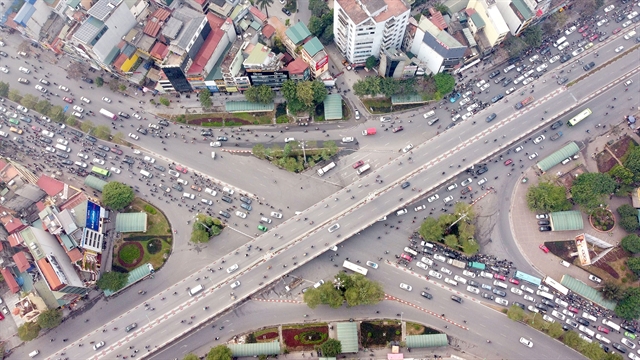 |
| An aerial view of the Ngã Tư Sở - Láng intersection. — VNA/VNS Photo Huy Hùng |
HÀ NỘI — The capital city began another pilot programme of traffic navigation at the Ngã Tư Sở - Láng intersection, aiming to alleviate the long-term congestion.
Authorities added that the programme would continue being adjusted if the current strategy did not work.
During this programme, vehicles on Láng Street will not be allowed to turn left to Tây Sơn Street but must go past the intersection 760 metres and turn around at the designated spot on Trường Chinh Street.
From this point, motorists can go straight ahead for Láng Street or turn right for Tây Sơn Street.
Vehicles going from Nguyễn Trãi Street towards the intersection are also banned from going straight to Tây Sơn Street or turning left to Láng Street. Instead, they must go to the designated turning point on Trường Chinh Street on their right.
A turning spot under the overpass bridge on Tây Sơn Street is also open.
Prior to Ngã Tư Sở, several other traffic congestion hotspots, such as Tố Hữu - Vũ Trọng Khánh - Hoàng Minh Giám - Nguyễn Chánh - Trần Duy Hưng and Hoàng Minh Giám - Hoàng Ngân - Nguyễn Thị Thập, also underwent traffic flow rearrangement programmes.
Reporting from the Tố Hữu - Vũ Trọng Khánh intersection, Giao Thông (Transport) newspaper said that traffic congestion is being alleviated when the heavy flow of vehicles from Tố Hữu Street must go straight ahead instead of turning left like in the past.
The situation at Trần Duy Hưng Road and the Hoàng Minh Giám - Hoàng Ngân route during rush hours and weekends has also improved.
A representative from the city’s Traffic Police Team No 7 said that motorists who don’t comply with the regulations are all recorded and dealt with.
Trần Hữu Bảo, deputy director of the Hà Nội transport department, said: “On days leading to Tết (Lunar New Year), traffic flows increase and exceed the capacity of several intersections. While there is congestion, there are no longer prolonged traffic jams.”
He added that the department was proposing the city’s People’s Committee officially implement the new flow directions following these pilot programmes while also reviewing all city routes for better traffic arrangement.
To optimise the organisation of traffic infrastructure, Hà Nội transport department also suggested the People’s Committee acquire software for traffic simulation and measurement, which would serve as a visual analysis tool for better management.
These tools, along with the accompanying equipment such as fly cams, are expected to cost over VNĐ1 billion (US$42,600).
Nguyễn Phi Thường, director of the capital city’s transport department, said that the application of traffic simulation software would visually illustrate the current state of traffic flows and the planned arrangement and contribute to the optimal conditions for traffic planning.
On Hà Nội’s efforts in rearranging the traffic, Đỗ Cao Phan, a lecturer at the Industrial University of HCM City, said that while the capital’s infrastructure cannot yet respond to the rise in the number of vehicles, traffic rearrangement is an immediate solution that could bring about fast results while is also cost-effective.
He said: “The people’s awareness plays a significant part in determining whether a traffic re-organising plan is successful.
“It is necessary to raise this awareness and active communication, alongside warnings and fines for violations.”
Phan also added that authorities need to monitor and adjust the plans according to the transport needs of the people, such as changing the distance to several turning points near the piloted intersections, lengthening traffic barriers on Nguyễn Trãi Street, and installing large, easy-to-read signs for motorists.
Hà Nội currently has 7.7 million vehicles, of which there are more than one million cars, 6.5 million motorbikes and 180,000 electric motorbikes, alongside approximately 1.2 million vehicles coming from other cities and provinces. The total figure increased by 4 to 5 per cent in recent years annually.
Meanwhile, the ratio of land for traffic to new urban areas is around 10.07 per cent, the land for static travel occupies less than one per cent and public transportation 17.8 per cent. — VNS


