 Environment

 |
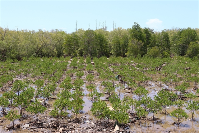
| The protective forest in the Gò Công coastal area in the southern province of Tiền Giang. Planting more trees will help reduce the impacts of climate change. — VNA/VNS Photo Hữu Chí |
Vietnamese experts hold that forecasting disaster risk levels needs to be built into a strategy as a basis for developing effective prevention and response plans in the context of climate change and natural disasters being unpredictable and increasing in number.
Việt Nam's coastal provinces play an important role in socio-economic development, but this is also an area greatly affected by tropical storms and other natural disasters.
According to the Ministry of Natural Resources and Environment (MoNRE), establishing different warning levels for natural disasters will help localities minimise impacts and overcome the consequences of natural disasters in a more reasonable and effective manner.
Floods’ impact
Nguyễn Quốc Khánh, deputy director of the Institute of Meteorology, Hydrology and Climate Change (IMHCC) under the MoNRE, said that in recent years, Việt Nam had recorded many typhoons, leading to high sea water levels and big waves that overflow and break dikes, as well as widespread flooding.
Some typhoons causing serious damage were Washi in 2005 in Hải Phòng City, Damrey in 2005 in Nam Định Province, Kalmaegi in 2014 in Quảng Ninh Province, Doksuri in 2017 in Nghệ An and Hà Tĩnh provinces, and Vamco in 2020 in Quảng Bình and Quảng Trị provinces.
Khánh also noted that climate change and rising sea levels tended to increase in frequency, duration and intensity, pushing up coastal erosion, saltwater intrusion and coastal flooding.
According to a climate change scenario posted in 2020, when the sea level rises by one metre, coastal provinces of the Red River Delta will be at risk of flooding across 20-40 per cent of its area, while the figures could reach 30-80 per cent in the Mekong Delta.
The reality is that in coastal areas, most of natural disaster risks are rising sea levels, typhoons, droughts and saltwater intrusion.
Typhoons and heavy rains leading to flooding, cause the greatest damage among those natural disasters.
For example, in provinces from Quảng Ninh to Thừa Thiên Huế, with warning for sea level rise reaching level five (the highest warning level), the flooding water could rise up five to six metres.
The disaster risk assessment study 2020, conducted by the World Bank and the Global Facility for Disaster Reduction and Recovery, shows that with the current trends in weather and climate, 11.8 million people in coastal areas of Việt Nam will be directly affected by floods; and US$1 million of gross domestic product (GDP) in agriculture will be lost due to flooding.
In addition, 42 per cent of coastal hotels are located in landslide areas, half of industrial zones are at risk of being affected by major floods and 22 per cent of schools and 26 per cent of medical facilities are at risk of being affected by major flooding.
Forecasting strategy
Deputy Director Khánh said that regions and localities should call for participation of forces depending on the level of natural disaster risk.
For example, natural disaster risk due to floods and inundations at level four would need participation of all ministries, branches and local authorities, which would determine the effectiveness of prevention, response, damage reduction and overcoming the aftermath of natural disasters.
“At the same height, the risk levels due to sea level rise for coastal areas will be different depending on local factors such as terrain, infrastructure, resilience and response capacity. This requires detailed building for risk levels based on local characteristics,” Khánh said.
He also said that currently, the IMHCC was implementing a number of ministerial and state-level projects on decentralisation and risk assessment of natural disasters in Việt Nam.
It was researching and building a system to warn of the risk levels of typhoons and tropical depressions according to hydrometeorological forecasts and applying them on a trial basis in the north central region.
The IMHCC was also researching scientific and technological solutions for multi-disaster management, building support tools for coastal areas, assessing the increasing level of natural disaster risks.
"Urgent solutions to prevent natural disaster risks include improving the effectiveness of marine hydrometeorology forecasting and warning; consolidating and upgrading the sea dyke system, ensuring resilience to frequent typhoons; increasing the amount of wave-breaking trees, developing protective forests and mangrove forests at river mouths and along the coast, and preserving natural coastal sand dunes," Khánh said.
He said that to upgrade and innovate the warning system, MoNRE proposed applying advanced technologies such as AI to improve the disaster forecasting accuracy, especially for floods and landslides.
More automatic monitoring stations with new technology should be added, especially in vulnerable areas, to ensure accurate and timely data collection and a disaster warning information system should be built in.
In addition, concerned agencies needed to develop education and communication programmes on climate change and natural disaster risks to raise people's awareness of self-prevention and protective measures against natural disasters.
They must review local planning and strategies including planning on infrastructure, land use, population and natural disaster prevention, especially in areas heavily affected by recent typhoons.
Response
 |
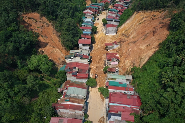
| Landslides caused by prolonged heavy rains in the northern province of Yên Bái. — VNA/VNS Photo Tuấn Anh |
In a seminar held in Hà Nội recently by the Tiền Phong (Vanguard) newspaper, Hoàng Đức Cường, deputy director of the Việt Nam Meteorological and Hydrological Administration (VNMHA), said that given current climate changes, natural disasters were becoming more unusual than before.
Along with that, the number of strong typhoons was increasing. Việt Nam had over the past five to six years suffered up to six strong typhoons per year.
Cường said that the VNMHA chose early warning as an important solution to minimise damage caused by natural disasters; and to have more data for forecasting, it was necessary to strengthen the radar system to reduce errors.
“This is a job that cannot be done in a few days. The inevitable trend is to apply the fourth industrial revolution, apply artificial intelligence (AI) to early warning,” said Cường.
“At the same time, it is necessary to cooperate internationally and share data, use advanced technology from bilateral and multilateral countries, and bring Việt Nam's data into the most modern models of countries in the world."
Sharing the same view, Vũ Anh Tuấn, deputy general director of the Việt Nam National Space Centre, said that many countries calculated that space technology could reduce natural disaster damage by up to 10 per cent.
Using space technology in the pre-disaster stage could identify risks, provide warnings and information to the hydrometeorological sector, or during natural disasters, it could help authorities to have timely response solutions.
Nguyễn Văn Hải, head of the Natural Disaster Response and Overcoming Division under the Department of Dyke Management and Natural Disaster Prevention and Control, said that many problems could be overcome in preventing and overcoming typhoons’ consequences.
Investment for prevention is the key task. Along with that, forecasting and warning needs to be promoted, according to Hải.
Currently in Việt Nam, in addition to natural factors, more attention should also be paid to man-made impacts such as road construction and hydroelectric dams the infrastructure impact before planning and construction, he said. VNS


