 Opinion

European arrivals surge as Việt Nam welcomes nearly 14 million foreign visitors in seven months
1.
|
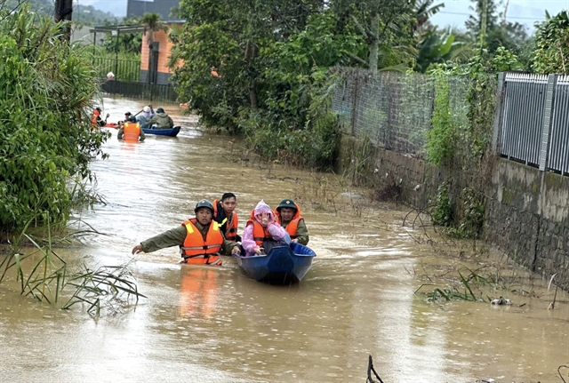
| Forces of Tu Mơ Rông District, Kon Tum Province fix a damaged position at Năng Nhỏ 1 spillway bridge, provincial road 678, caused by Typhoon Conson on September 12. — VNA/VNS Photo |
Deputy Director of the Việt Nam Meteorological and Hydrological Administration Hoàng Đức Cường talks to Quân Đội Nhân Dân (People’s Army) newspaper on applying new technology in forecasting adverse natural events.
What are the challenges in forecasting the two most prominent natural disasters in Việt Nam: typhoons and floods?
In Việt Nam, whenever natural disasters are mentioned, typhoons and floods are always the most common. Typhoons usually emerge from the Western Pacific Ocean or the East Sea (South China Sea), where our current monitoring system is not adequate. Should a typhoon occur here, we have no data regarding its structure and direction, thus leading to us relying heavily on imperfect satellite data. Furthermore, we only analyse and use data from weather observation stations and mathematical models to forecast hydrometeorological events, whereas our radar capabilities are inadequate. Therefore, only when the typhoon approaches land can radar provide a clearer picture and characteristics of the typhoon. To better manage and observe typhoons, Việt Nam should pay great attention to developing new monitoring systems such as radars, drones, weather monitoring aircraft, and stratospheric measurement tools.
Regarding forecasting floods, we lack monitoring and geographic data; information and data about vegetation structure, soil properties and changes in land use, causing difficulties in forecasting. Việt Nam has big river systems, including the Red River and the Mekong River which are located downstream of river basins with transnational water sources, which cause challenges for monitoring and observation of water sources coming from upstream of these two river basins.
Have Việt Nam's recent investments in monitoring and measuring tools met the needs of forecasting?
In recent years, our monitoring and measuring systems have been gradually updated, thus improving our forecast capability and quality. For instance, the salinity monitoring and measuring networks have enabled us to actively manage salinity, droughts better than ever before. We have been able to forecast severe saltwater intrusion and droughts in recent years, which helped to reduce the economic and environmental damage to the Mekong Delta substantially.
With the upgrade of our system of ten weather radars, we can monitor the typhoons and tropical depressions’ structures and characteristics when they approach land, thus leading to better forecasts of the storms’ magnitudes, directions and their abilities to generate heavy showers and strong winds.
However, the monitoring network is still thin in comparison with real demand. The real-time monitoring data is inadequate, especially in mountainous areas which often suffer heavy rains, flash floods and landslides. Moreover, the measuring tools of hydrometeorological monitoring networks lack synchronisation, the transmission of data and information for forecasting fails to meet the needs of immediacy, and automatic forecasting technology is not widely applied.
Flash floods and landslides always give the hydrometeorological experts headaches. What are the Việt Nam Meteorological and Hydrological Administration (VNMHA)’s solutions to improve its forecast quality?
Flash floods and landslides are adverse natural events that usually occur in the rainy season, which are quick, local and destructive. In recent years, the VNMHA has initially improved its flash flood and landslide forecasts. We have also utilised artificial intelligence in forecasting flash floods and landslides. However, in Việt Nam, the big data sources on this particular aspect are still fragmented and the monitoring network is prioritised for upgrading in recent years but has not yet met demand. Artificial intelligence can only be fully utilised when our data sources are developed adequately. — VNS
Opinion
 Opinion
 Opinion
 Opinion
 Opinion
 Opinion
 Opinion
UNICEF Representative in Việt Nam Rana Flowers talks to the press about impacts of COVID-19 on children's mental health on the launch of the State of the World’s Children 2021 report "On My Mind: Promoting, protecting and caring for children’s mental health".
 Opinion
To mark South Korea's National Foundation Day on October 3, the ambassador to Việt Nam, Park Noh-wan, wrote to Việt Nam News.
 Opinion
High-quality human resources are an important factor in economic development and Việt Nam urgently needs a strategy to develop a more qualified workforce.
 Opinion
 Opinion
 Opinion
 Opinion
 Opinion
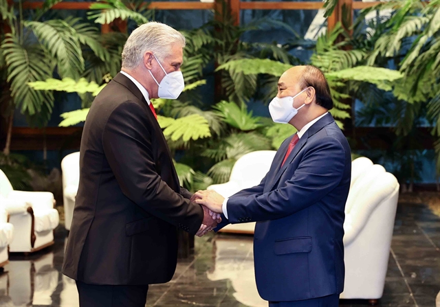
During the visit of President Nguyễn Xuân Phúc (September 18-20) and his meeting with President of Cuba Miguel Diaz Canel issues of common interest were discussed at length.