 Life & Style


Việt Nam retain Asian Pencak Silat Championships title
1.
|
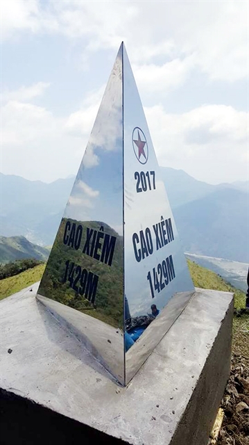
| Mt Cao Xiêm peak has an altitude of 1,429m above sea level. — Photo baoquangninh.com.vn |
Lâm Giang
HÀ NỘI — When it's safe to travel again, you could do worse than a trip to Mount Cao Xiêm in Bình Liêu District, Quảng Ninh Province, to indulge in the wild beauty of the mountains.
Located in Lục Hồn Commune, Mt Cao Xiêm is not a hugely popular tourist destination due to the tricky terrain on the mountain considered the roof of the province.
With an altitude of 1,429m above sea level, in any village of Bình Liêu you can see the imposing mountain peak. On harvest days, local people look up at Mt Cao Xiêm to see when rain is on the way so they know when to rapidly collect their rice and maize.
Few people have reached the top of this mountain, giving Cao Xiêm a strange and mysterious allure.
To discover Mt Cao Xiêm peak, we had to walk about 7km, mainly on trails along the slopes with lots of rocky mountains covered with clouds year-round and through immense grass hills.
There are three ways to reach the peak. The first is from Cao Thắng Village in Lục Hồn Commune. The second is from Lục Ngù Village in Húc Động Commune, and the third is from Ngàn Mèo Village in Lục Hồn Commune. We chose the first method and parked our car at a local house and walked for about 1 hour and 30 minutes to reach the top.
|
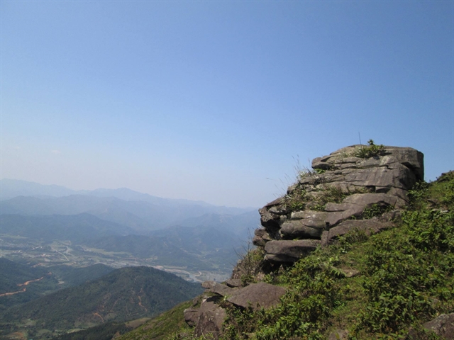
| View from the top of Cao Xiêm mountain. — Photo quangninh.gov.vn |
During the journey to the top of Mt Cao Xiêm, we had a chance to see the villages of the Dao and Sán Chỉ ethnic minority people in Bình Liêu District, where the houses have fascinating architecture.
Following the path, going through the vast forests, we saw beautiful wildflowers and ate wild fruit, giving us an energy boost.
After passing through immense pine forests, steep slopes and streams, a green steppe with very fresh air appeared.
On this grassland, we stopped to enjoy the harmony with mountains and forests, with our journey to conquer the mountain at the halfway point.
Continuing the journey, we traversed a pine forest for about 2km, steep mountain slopes and winding trails dotted with big rocks.
|
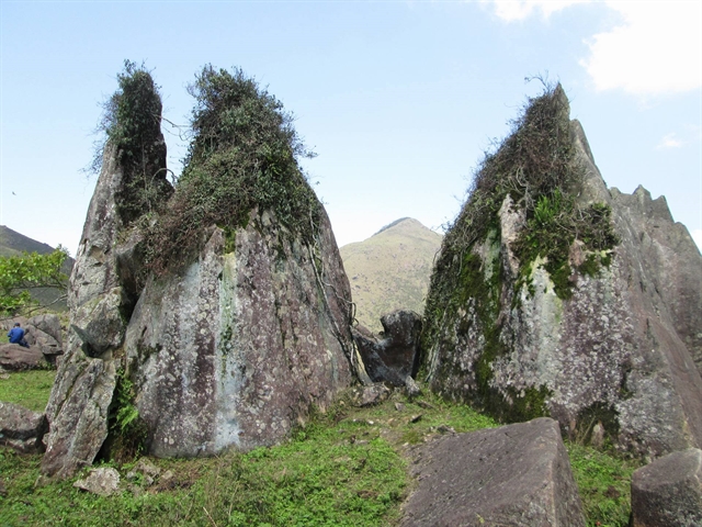
| Large twin rocks on the top of Mt Cao Xiêm. — Photo quangninh.gov.vn |
On foggy days, this road is the biggest challenge in the journey to conquer Mt Cao Xiêm. You will see clouds entwined with each step. Because of dense fog, it's hard to see more than 10m apart, so everyone needs to stick to each other to not get lost.
On beautiful days, everything becomes easier. While walking you can stop at each stage to rest and admire the scenery and enjoy the cool breeze and fresh air of the northeastern mountains.
The journey was arduous and we were thrilled to reach the top. Standing on the highest peak of the Cao Xiêm mountain range, we could see a large area.
From the east of the mountain top, we could look beyond Hải Hà and Đầm Hà districts to the Gulf of Tonkin. From the west, we could see over the high mountains between the Việt Nam-China border.
From the south, we saw Bình Liêu valley and beyond to the low hills in Tiên Yên District. From the north, we could see the imposing Cao Ly and Quảng Nam Châu mountains.
On the top of Cao Xiêm, there are still trenches and roads opened up over the mountain. Here, in the past, a flag was planted showing the sovereignty of Việt Nam. For this reason, the Sán Chỉ ethnic people call Cao Xiêm mountain "Kèo Kăm Khây" (mountain of raising flag), while the Tày people call it "Khau Cẳm Cờ".
In 2017, Bình Liêu District built a shiny triangular landmark on the top of Mt Cao Xiêm.
When standing on the peak, we also admired the natural stone walls lasting kilometres, which have been called a "miniature Great Wall" of Bình Liêu.
|
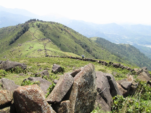
| The road to the top of Cao Xiêm mountain. — Photo quangninh.gov.vn |
According to local people, these stone walls were created by the people of Lục Hồn and Húc Động communes to divide their territory and prevent their livestock from wandering off.
There is another story that, in the past, in Lục Hồn and Húc Động communes, there were a couple in love that they often sneaked up the mountain to date. Their parents and villagers found out about them and forbade them from seeing each other. To avoid the same thing happening again, the people of the two communes built the stone fence.
Leaving the peak, we saw the intersection between heaven and earth of the northeastern border area of the country and wished that land would forever be fresh and peaceful. — VNS
Life & Style
 Life & Style
 Life & Style
 Life & Style
 Life & Style
 Life & Style
 Life & Style
A book project to promote Vietnamese culture to Vietnamese and international readers called “Tủ Sách Văn Hóa Việt” (Bookshelf of Việt Nam Culture) has been launched.
 Life & Style
 Life & Style
Trần Anh Khoa won the best actor award at the 18th Asian Film Festival in Rome, Italy last month for playing the title character in the movie Ròm. Ròm was the first Vietnamese film to win the top award in the New Current section at the Busan International Film Festival in 2019 and the best first feature film award at Fantasia IFF 2020. Khoa is currently studying film production at Confederation College, Canada. He spoke to kenh14.vn about his role in Ròm.
 Life & Style
An online photo contest seeking to spread a positive message of environmental protection for the wider community has kicked off the first Miss Eco Vietnam pageant.
 Life & Style
 Life & Style
 Life & Style
An online concert connecting musicians from Việt Nam, Germany, France and Ghana will be held on July 17.
 Life & Style