 Opinion

Việt Nam plans inspection of five jewellery, gemstone businesses
1.
Vietnam News Agency talks to Trần Tân Văn, Director of the Việt Nam Institute of Geosciences and Mineral Resources, about the serious landslides in central region that have resulted in great losses in human life and property.
|
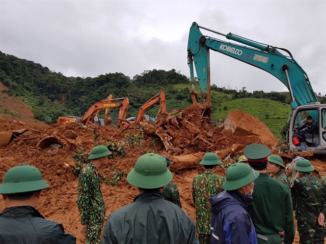
| Military and rescue personnel excavate a landslide-hit area in Quảng Trị Province on October 19 to look for bodies of victims.— VNA/VNS Photo |
Vietnam News Agency talks to Trần Tân Văn, Director of the Việt Nam Institute of Geosciences and Mineral Resources, about the serious landslides in central region that have resulted in great losses in human life and property.
What are the causes of the devastating landslides we have witnessed in central Việt Nam?
There are two forces at play – a driving and a resisting force – which in normal conditions, the two are in equilibrium and the slope remains stable, but once the driving force wins out then the landslides happen.
The strength of the soil is determined by cohesion and friction. A dry slope means greater cohesion and friction and less chance for landslides to occur, but once a slope is soaked in water, these two forces decrease by a great deal, therefore landslides usually occur after persistent downpours.
The type of soil or rock is also a determining factor, some are sturdier while others are softer and more prone to being broken up by erosion from wind and water.
But ultimately, I want to stress that water is number one enemy of a slope. Studies I followed have pointed out that rainfall of 100mm a day, or tens of millimetres a day but lasting a whole week to 10 days is enough to inundate the soil.
Some of the notable points in recent incidents witnessed in Việt Nam’s central regions that I want to focus on. First, the soil is saturated and “liquefied” after prolonged rains. Second, landslides usually happen where the foot of a naturally formed slope is carved in to make way for infrastructure projects, mostly mountain roads. Third, it seems that the landslides usually happen at night, so maybe there is some correlation between the changes in temperature and water pressure.
Việt Nam has ‘landslide mapping’ of 20 provinces, but why couldn’t we forecast reliably the occurrence of landslides?
It’s been eight years since we commenced the project on surveying, assessment, and landslide risk zones in mountainous regions, and so far, we have made landslide mapping of 1:50,000 ratio for 22 provinces and hazard risk zonation of 1:50,000 ratio for 15 provinces.
We have also started to make larger maps in high risks areas. So far, mapping has been done in 50 communes.
In the short term, these maps could help identify the landslide-prone areas to form a response – including avoiding the area altogether or evacuation of people from low-risks areas when the risks became unmanageable. In the longer term, the maps could help adjust socio-economic development plans, infrastructure or residential plans.
Theoretically it is possible to forecast the slide and in fact, a number of developed countries and territories such as Japan, South Korea, the United States and especially Hong Kong have deployed surveillance of some specific important slopes, or even installed a number of real-time monitoring devices communicating via the internet which could predict the time of landslide with considerable degree of accuracy.
But again, they only do this for important slopes, for example, ones along highways or in the vicinity of major residential centres. For natural slopes in rural and mountainous areas in Việt Nam, such expensive measures remain just a dream.
Mapping and zonation are still the primary methods used in these areas, the important thing is how effective we use them.
Other than natural triggers, do you think that construction of hydropower plants and other mountainside projects play a role in the occurrence of landslides?
All construction activities – including building of roads, hydropower plants, houses, etc. – that carve out a part from the foot of a natural slope will disrupt the balance of that slope. But if the survey for a project is done carefully and the construction carried out properly, the impacts might be managed, otherwise the very process of construction could lead to landslide.
Take building dams to store water for hydroelectricity for example. Without the obstructing dams, the water level in rivers and streams will remain low. But when there is a dam, the water level of the reservoir will rise from a few meters to several tens of meters higher than normal, causing the groundwater level in the land to rise as well, resulting in saturation of the soil and destabilisation of the slope.
What about earthquakes, when small-scale earthquakes seem to be increasing in frequency in our country?
Earthquake could be a contributing factor – it could fracture the soil and rock structures, weakening the soil. The more concerning earthquakes usually happen in the northwestern mountainous regions of Việt Nam like Điện Biên or Lai Châu provinces.
The smaller scale earthquakes on the other hand could strike any sufficiently large hydropower projects, which have been reported at Sông Tranh 2 hydropower project in central province of Quảng Nam multiple times over the past years.
What are your recommendations for localities with high risks of landslides?
The prolonged rain and flooding in central Việt Nam the past few weeks can be considered historic, shattering every known record. Despite maxed out relief efforts from the Government and the community, the severity and scale of this disaster has gone beyond our ability to cope.
Certainly, after this episode of rainstorms, our disaster prevention and mitigation work will need to change fundamentally. For example, natural disease monitoring, warning, response, and rescue activities will have to be carried out at even the grassroots level, commune level, village level and at each household.
Disaster insurance policies will need to be implemented, the forestlands need to be protected and conserved for recovery, while much more careful consideration should go into the decision-making processes regarding all hydropower, irrigation, transport, and infrastructure projects. — VNS
Opinion
 Opinion
 Opinion
 Opinion
 Opinion
 Opinion
 Opinion
 Opinion
Mai Trọng Thái, director of the Environmental Protection Sub-Department under the Hà Nội Department of Natural Resources and Environment, talks to Tài Nguyên and Môi Trường (Natural Resources and Environment) newspaper about the need to complete a legal policy to solve pollution in traditional trade villages.
 Opinion
 Opinion
 Opinion
Ahead of Hà Nội's upcoming Party Committtee Congress, Vũ Hà, deputy director of the city's Department of Transport, talks to Tiền Phong (Vanguard) newspaper about his department’s plans to improve transport infrastructure in the capital.
 Opinion
Spanish Ambassador Pilar Méndez Jiménez sends a message to Việt Nam News on Spain's National Day
 Opinion