 Life & Style


Việt Nam-Laos trade targets US$10 billion
1.
Adventurous travellers are no strangers to trekking, to the feeling of being one with nature, resting on a lush green hillside being cooled by a gentle breeze. This is what the Tà Năng–Phan Dũng has to offer.
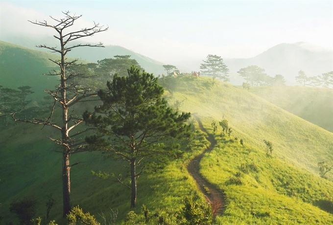 |
| Nature’s orchestra: We are awakened by the melodious songs of the forest birds early in the morning. Peeking through the tent window, we see the lush green meadow stretching endlessly. |
By Hoàng Linh
Adventurous travellers are no strangers to trekking, to the feeling of being one with nature, resting on a lush green hillside being cooled by a gentle breeze. This is what the Tà Năng–Phan Dũng has to offer.
The 55km trekking route spans three provinces in southern central provinces of Lâm Đồng, Ninh Thuận and Bình Thuận - descending from an elevation of 1,100 metres at its western-most point to 500m. The route starts from Tà Năng in Đức Trọng District of Lâm Đồng and ends at the mountainous town of Phan Dũng, Tuy Phong District of Bình Thuận.
Setting off on the bumpy basalt, soil-filled route at a tilt of 30-40 degrees at points, we come to realize that this trek, while not for the tourist seeking relaxation and well-serviced amenities, is of incomparable beauty.
The route looks like an emerald silk flow of lush green meadow and patches of pine trees bordering the forests; making a magnificent yet delicate transition from the Central Highlands to the central coastal area unfolding before the adventurous trekkers.
 |
| At one with nature: The Tà Năng– Phan Dũng trekking route runs from the Central Highlands to the central coastal area. |
“Trekking through this route, I can clearly feel the ethereal fog layers hovering above, hugging the hilltops, blowing cool breezes; I can feel the warm sparkling sunlight shining through the foliage onto the grass field full of crystal-like dew drops; various melodies of different birds echo endlessly from the hillsides and forests creating a mysterious concert that brings us to a seemingly surreal world,” wrote Trần Hoàng Đức, a member of our trekking group.
Trekkers can choose any hillside to put up a tent for an overnight stop and experience a peaceful evening beside a warm, glowing bonfire under the shining stars.
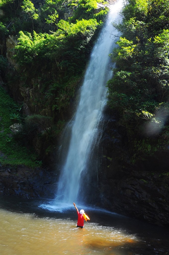 |
| Crashing crescendo: The Yavly waterfall emerges crashing in front of our eyes, washing away all the sweat and tiredness of our long journey. |
Following the advice of previous trekkers, we pay attention to the triangle landmark where the three provinces of Lâm Đồng, Ninh Thuận and Bình Thuận converge. Nearby is the Yavly Waterfall, where the water plunges down in a crashing crescendo to the bottom of a lake, creating white bubbles, mingles with the flow of nearby streams whispering to the mountains.
“Dipping in the fresh cool water of the waterfall is quite therapeutic: it washes away all the stress and tiredness. What an absolutely relaxing experience!” marveled my friend Lê Xuân Hưng.
Dầu, the highest point of the trekking route, is a wonderful spot to watch as dawn starts to break and the night fog dissolves among the green foliage to be replaced by the glowing red sunshine of early morning. We walk through the dreamy, romantic landscape stretching from one hillside to the next until dusk, when the Tà Năng–Phan Dũng trek dons its mysterious and sombre cloak. — VNS
Essential information for the Tà Năng–Phan Dũng trek*Personal items: Specialised shoes for trekking, a 60-65 litre capacity backpack, sleeping bag, tent, hat, scarf, clothes, items for keeping warm, flashlight, raincoat, medicine and first-aid kit, backup battery. *Food and drinks: -Water: at least 5 litres. *Map -Download the map app MapsMe to navigate. After installing, one can download the Viet Nam map for supplemental information. Link: Maps.Me https://maps.me/en/home |
Life & Style
 Life & Style
 Life & Style
 Life & Style
 Life & Style
 Life & Style
 Life & Style
Việt Nam has plenty of modern tourism resources but has not taken advantage of them, experts said yesterday.
 Life & Style
Monsoon Music Festival (MMF), Việt Nam’s biggest music event, will storm the city tonight with a repertoire featuring a lineup of Vietnamese and international artists.
 Life & Style
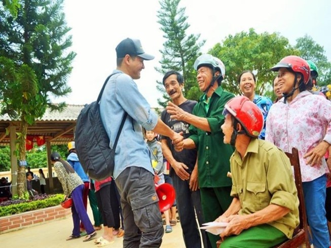
Vietnamese celebrities have launched fund raising campaigns to help flood victims in the center of the country. Some have traveled to the affected areas to deliver necessities to people in need.
 Life & Style
The Rooftop's return will be marked with a marvelous music show on October 22nd 2016.
 Life & Style
A decent facility with passionate teachers is the first impression one has when visiting the Kianh Foundation Centre in central Quảng Nam Province, which is offering near free care and treatment for nearly 100 children with disabilities.
 Life & Style
Contemporary life in Hà Nội is reflected through various photos displayed at an on-going exhibition.
 Life & Style
Famous singer Tùng Dương will perform at the 19th Toyota Classics 2016 concert at HCM City’s Opera House on November 11.
 Life & Style
Multi-faceted entertainer Ohene Cornelius and saxophone player Stanford Reid from New York will host a performance at Piu Piu on October 22.
 Life & Style
Hard Rock Café Vietnam will host two Halloween parties on October 28 and 29.