
National Assembly approves Nguyễn Tiến Hải as Minister of Home Affairs
1.
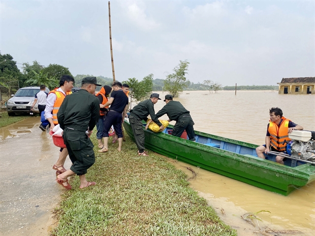 |
| Police officers of Hà Tĩnh Mobile Police Force delivering necessities in the aftermath of a flood on November 1. — VNA/VNS Photo Hữu Quyết |
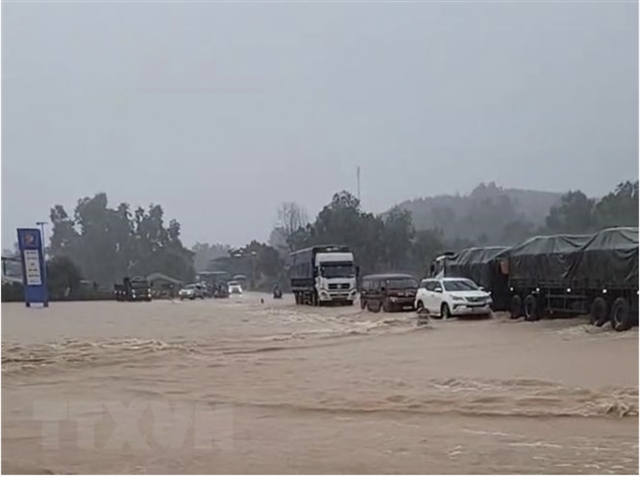
HÀ NỘI — Floods, landslides, and other natural disasters are common occurrences in Việt Nam, often characterised by their rapid and localised impacts.
Việt Nam, situated in a tropical monsoon climate region, is prone to extended periods of heavy rainfall, diverse topography, and a dense network of rivers and streams, which collectively elevate the risk of flooding and landslides.
Hoàng Văn Đại, the Deputy Director of the National Centre for Hydro-Meteorological Forecasting (NCHMF), explains that intense, short-term rainfall in small watersheds or upstream flash floods can trigger flooding and landslides in various areas. Furthermore, some high-risk areas for these disasters have not yet been properly identified. In addition to these natural factors, human activities such as deforestation and improper construction practices contribute to environmental degradation, increasing the likelihood of floods and landslides.
Floods and landslides are particularly dangerous as they often occur on a small scale and with short lead times, making prediction and warning challenging. Currently, weather forecasts provide general alerts for potential floods and landslides at the district or commune level, lacking precise details regarding the timing, location, intensity, and affected areas.
According to Đại, due to the severity and extensive damage caused by these disasters, it is essential to focus on improving early warning systems to reduce their impact. Preventive measures should take precedence over reactive approaches, as investment in preparedness proves to be much more effective than addressing the aftermath of these disasters.
To minimise the damage caused by floods and landslides and ensure the safety of people, property, and infrastructure while promoting stable economic and social development, the NCHMF is implementing a comprehensive set of measures. The primary focus is on the adoption of modern technology to enhance the precision of flood and landslide alerts, including more detailed rainfall thresholds.
In the long term, the meteorological department will adhere to the government's decision which approves the project "Early Warning for Landslides and Floods in Mountainous and Midland Areas of 37 Provinces and Centrally Run Cities from 2023 to 2030."
This project aims to establish an integrated early warning system and a comprehensive risk zoning map for landslides and floods, tailored to the specific characteristics of each region. It also involves communication and information sharing with local communities to enhance their ability to respond to these disasters.
By 2025, the NCHMF plans to complete a 1:50,000-scale risk zoning map, displayed on a 1:25,000 geographical information background, for the 37 mountainous and midland provinces. By 2030, they aim to finalise a larger-scale risk zoning map for high-risk areas and an extensive early warning system interconnected with various government bodies, local agencies, and the public.
The department will review and develop legal documents, technical standards, and procedures related to risk zoning and early warning for landslides and floods. They will also collect data and create situation maps to assist in the preparation of risk zoning maps. Ultimately, the focus is on increasing the community's capacity to communicate and utilise early warning information.
Furthermore, the NCHMF will establish a real-time flood and landslide warning system, with collaboration between management agencies, warning and forecasting units, and the local population for data collection, analysis, and response. This system will include updates on landslides, floods, economic and social information, and damage assessments to improve early warning effectiveness. Investment in information technology infrastructure will support the operation of the early warning system. — VNS
 Environment
 Environment
 Environment
 Environment
 Environment
 Environment
 Environment
 Environment
 Environment
 Environment
 Environment
 Environment
 Environment
 Environment