 Life & Style

U23 Việt Nam ready to face Malaysia
1.
A collection of 40 ancient maps, which indicated Hoàng Sa (Paracel) Islands belong to Việt Nam, and two atlas were on display for the first time at a conference: Conflict in the South China Sea (or East Sea) in the US last week.
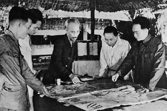
 |
| A map of Việt Nam’s sea on display for the first time in the US last week. VNS Photo Trần Thắng |
ĐÀ NẴNG — A collection of 40 ancient maps, indicating the Hoàng Sa (Paracel) Islands belong to Việt Nam, and two atlases were displayed for the first time at a conference: Conflict in the South China Sea (called East Sea by Việt Nam) at Yale university in Connecticut, the US, last week.
The maps are part of a collection of 150 maps belonging to the president of the Institute for Vietnamese Culture and Education, Trần Thắng, an American of Vietnamese origin. The institute is a non-profit organisation founded in New York in 2000.
Thắng said by email yesterday that it’s the first time that the ancient maps, which were published by Việt Nam (1618-1859); England, America, France, Germany and Scotland (1826 and 1980), and China, were exhibited in the US.
He donated a 150-map collection to Đà Nẵng City’s Institute for Socio-Economic Development in 2012, 40 of which are now being displayed in the US
Thắng said 20 maps published by Việt Nam and western countries (1618-1859) showed that the Hoàng Sa (Paracel) Islands belongs to Việt Nam.
Twenty maps published by western countries (1826 and 1980) indicated that the frontier of southern China is Hainan island.
The Vietnamese-American also said he found two Chinese atlases which were published by the Directorate General of Posts, Ministry of Transportation of the Republic of China in 1933 (29 maps) and one atlas of the Chinese Empire, published by the China Inland Mission in 1909 (23 maps). All of them also indicated that the frontier of southern China is Hainan Island.
According to the Institute for Socio-Economic Development of Đà Nẵng, the collection of maps donated by Thắng comprise 68 old maps of China showing that China did not have the Paracel and Spratly islands; six maps that indicate those islands belonged to Việt Nam; five maps of the Southeast Asian region that show the Paracel and Spratly archipelagoes are under Viet Nam’s sovereignty. — VNS
Life & Style
 Life & Style
 Life & Style
 Life & Style
 Life & Style
 Life & Style
 Life & Style
People choose hats at a hat market in the Chuông Village, Thanh Oai District in Hà Nội. -- VNS Photo Việt Thanh
 Life & Style
A group of ambassadors to Việt Nam from several countries will begin their excursion to Sơn Đoòng Cave, the central province of Quảng Bình tomorrow.
 Life & Style
Lao Động (Labour) newspaper reporter Việt Văn won first prize in the food category at the International Color Awards – Los Angeles in the United States for his photo “The Breakfast”.
 Life & Style
The country’s famous publishing house Kim Đồng opened its first store in HCM City’s District 1.
 Life & Style
Bold Strokes, an event to celebrate the contemporary art in Việt Nam which gathers many Vietnamese and foreign artists, will take place on Wednesday night at the Art Vietnam Gallery.
 Life & Style
Đức Hùng, 26, only emerged on the scene following his participation in Giọng Hát Việt (The Voice of Vietnam 2013), and since then has turned to songwriting and producing.
 Life & Style
Popular designer Adrian Anh Tuấn will debut his latest collection titled The Superstar in HCM City, Hà Nội and California in the United States soon.
 Life & Style
Thirty free shows featuring folk songs in the central province of Nghệ An will be held for visitors at Kim Liên Village this summer.
 Life & Style
A movie by director Đặng Nhật Minh tiled Thương Nhớ Đồng Quê (Nostalgia for the Countryside) was screened last night, kicking off the Việt Nam Film Festival in New Delhi.
.jpg)